Near Manassas in Prince William County, Virginia — The American South (Mid-Atlantic)
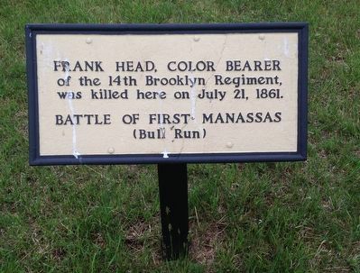
Frank Head
Battle of First Manassas (Bull Run)
Topics. This historical marker is listed in this topic list: War, US Civil. A significant historical date for this entry is July 21, 1861.
Location. 38° 48.786′ N, 77° 31.428′ W. Marker is near Manassas, Virginia, in Prince William County. Marker can be reached from Sudley Road (Virginia Route 234) half a mile south of Lee Highway (U.S. 29), on the left when traveling south. Marker is located at the end of a short trail, 500 feet west of the Visitor Center. Touch for map. Marker is at or near this postal address: 6511 Sudley Rd, Manassas VA 20109, United States of America. Touch for directions.
Other nearby markers. At least 8 other markers are within walking distance of this marker. 7th Georgia Markers (about 500 feet away, measured in a direct line); Position 7th G.A. Regt. (about 500 feet away); Lieutenant Ramsey (about 500 feet away); Artillery Duel (about 500 feet away); Short of Total Victory (about 600 feet away); Wade Hampton (about 600 feet away); Henry Hill (about 700 feet away); Invaded Farmland (about 700 feet away). Touch for a list and map of all markers in Manassas.
Also see . . . Manassas National Battlefield Park. National Park Service (Submitted on May 13, 2016.)
Credits. This page was last revised on June 16, 2016. It was originally submitted on May 13, 2016, by Shane Oliver of Richmond, Virginia. This page has been viewed 499 times since then and 25 times this year. Photos: 1, 2, 3. submitted on May 13, 2016, by Shane Oliver of Richmond, Virginia. • Bernard Fisher was the editor who published this page.


