Sully near Herndon in Fairfax County, Virginia — The American South (Mid-Atlantic)
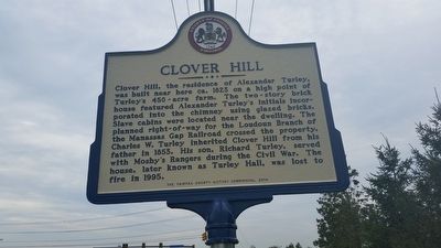
Clover Hill
Erected 2014 by The Fairfax County History Commission.
Topics and series. This historical marker is listed in these topic lists: African Americans • Agriculture • Architecture • War, US Civil. In addition, it is included in the Virginia, Fairfax County History Commission series list. A significant historical year for this entry is 1823.
Location. 38° 54.683′ N, 77° 25.313′ W. Marker is near Herndon, Virginia, in Fairfax County. It is in Sully. Marker is at the intersection of Centreville Road (Virginia Route 657) and Lees Corner Road (Virginia Route 645), on the right when traveling south on Centreville Road. Touch for map. Marker is at or near this postal address: 13623 Flintwood Pl, Herndon VA 20171, United States of America. Touch for directions.
Other nearby markers. At least 8 other markers are within walking distance of this marker. Sully Historic Site (approx. 0.3 miles away); Richard Bland Lee: Gentleman Farmer (approx. 0.3 miles away); "Loudoun Branch" of the Historic Manassas Gap Railroad (approx. 0.4 miles away); Excavating a 19th century Tenant Structure (approx. 0.4 miles away); An 18th Century Enslaved Community at Sully (approx. half a mile away); Richard Bland Lee Served His Country (approx. half a mile away); The Sully Farms (approx. half a mile away); Old Barn and Other Farm Buildings (approx. half a mile away).
Additional keywords. slavery, slave labor
Credits. This page was last revised on September 21, 2023. It was originally submitted on June 8, 2016, by Stephen Nicoud of Herndon, Virginia. This page has been viewed 1,507 times since then and 80 times this year. Photo 1. submitted on June 8, 2016, by Stephen Nicoud of Herndon, Virginia. • Bernard Fisher was the editor who published this page.
Editor’s want-list for this marker. Wide shot of marker and its surroundings. • Can you help?
