DeValls Bluff in Prairie County, Arkansas — The American South (West South Central)
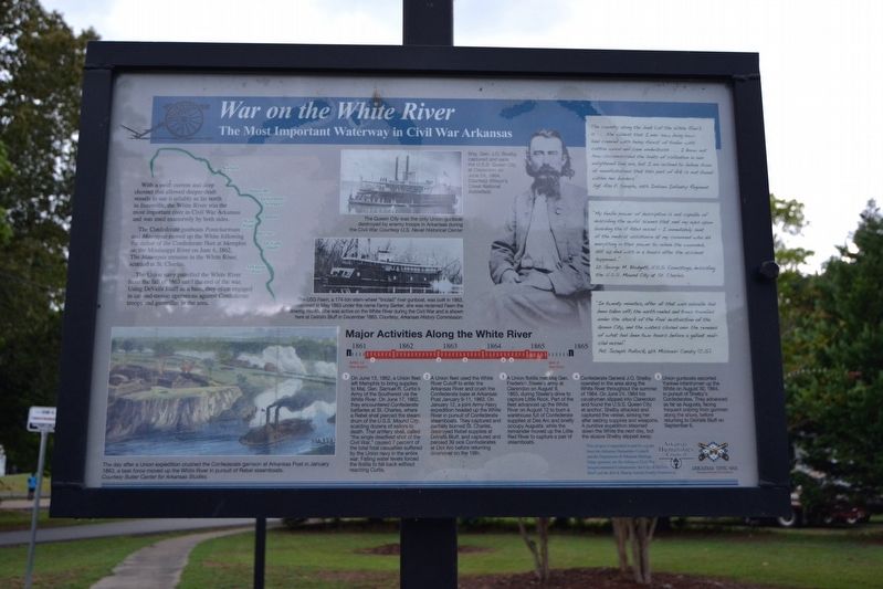
War on the White River
The Most Important Waterway in Civil War Arkansas
With a swift current and deep channel that allowed deeper-draft vessels to use it reliably as far north as Batesville, the White River was the most important river in Civil War Arkansas and was used extensively by both sides.
The Confederate gunboats Pontchartrain and Maurepas moved up the White following the defeat of the Confederate fleet at Memphis on the Mississippi River on June 6, 1862. The Maurepas remains in the White River, scuttled at St. Charles.
The Union navy patrolled the White River from the fall of 1863 until the end of the war. Using DeValls Bluff as a base, they often emerged in cat-and-mouse operations against Confederate troops and guerrillas in the area.
Major Activities Along the White River
On June 13, 1862, a Union fleet left Memphis to bring supplies to Maj. Gen. Samuel R. Curtis’s Army of the Southwest via the White River. On June 17, 1862, they encountered Confederate batteries at St. Charles, where a Rebel shell pierced the steam drum of the U.S.S. Mound City, scalding dozens of sailors to death. That artillery shell, called “the single deadliest shot of the Civil War,” caused 7 percent of the total fatal casualties suffered by the Union navy in the entire war. Falling water levels forced the flotilla to fall back without reaching Curtis.
A Union Fleet used the White River Cutoff to enter the Arkansas River and crush the Confederate base at Arkansas Post January 9-11, 1863. On January 12, a joint Army-Navy expedition headed up the White River in pursuit of Confederate steamboats. They captured and partially burned St. Charles, destroyed Rebel supplies at DeValls Bluff, and captured and paroled 39 sick Confederates at Des Arc before returning downriver on the 19th.
A Union flotilla met Maj. Gen. Frederick Steele’s army at Clarendon on August 9, 1863, during Steele’s drive to capture Little Rock. Part of the fleet advanced up the White River on August 12 to burn a warehouse full of Confederate supplies at Des Arc and briefly occupy Augusta, while the remainder moved up the Little Red River to capture a pair of steamboats.
Confederate General J.O. Shelby operated in the area along the White River throughout the summer of 1864. On June 24, 1864 his cavalrymen slipped into Clarendon and found the U.S.S. Queen City at anchor. Shelby attacked and captured the vessel, sinking her after seizing supplies and weapons. A punitive expedition steamed down the White the next day, but the elusive Shelby slipped away.
Union gunboats escorted Yankee infantrymen up the White on August 30, 1864, in pursuit of Shelby’s Confederates. They advanced as far as Augusta, facing frequent
sniping from gunmen along the shore, before returning to DeValls Bluff on September 6.
“The country along the bank [of the White River] is ... the wildest that I ever saw, being low-land covered with heavy forest of timber with cotton wood and cane underbrush ... I know not how circumscribed the limits of civilization in our enlightened land are, but I am inclined to believe from all manifestations that this part of Ark. is not found within her borders.”
Sgt. Asa E. Sample, 49th Indiana Infantry Regiment
“My feeble power of description is not capable of describing the awful scenes that met my eyes upon boarding the ill-fated vessel — I immediately sent all the medical assistance at my command who did everything in their power to relieve the wounded, still 50 died within 4 hours after the accident happened ...”
Lt. George M. Blodgett, U.S.S. Conestoga, describing the U.S.S. Mound City at St. Charles
“In twenty minutes, after all that was valuable had been taken off, the earth reeled and trees trembled under the shock of the final destruction of the Queen City, and the waters closed over the remains of what had been two hours before a gallant mail-clad vessel.”
Pvt. Joseph Pollock, 6th Missouri Cavalry (C.S.)
(Left Illustration Caption)
The day after a Union expedition crushed
the Confederate garrison at Arkansas Post in January 1863, a task force moved up the White River in pursuit of Rebel steamboats.
Courtesy Butler Center for Arkansas Studies.
(Upper Middle Image Caption)
The Queen City was the only Union gunboat destroyed by enemy troops in Arkansas during the Civil War.
Courtesy U.S. Naval Historical Center
(Lower Middle Image Caption)
The USS Fawn, a 174-ton stern-wheel “tinclad” river gunboat, was built in 1863. Commissioned in May 1863 under the name Fanny Barker, she was renamed Fawn the following month. She was active on the White River during the Civil War and is shown here at DeValls Bluff in December 1863.
Courtesy, Arkansas History Commission.
(Right Image Caption)
Brig. Gen. J.O. Shelby captured and sank the U.S.S. Queen City at Clarendon on June 24, 1864.
Courtesy Wilson’s Creek National Battlefield.
Topics. This historical marker is listed in these topic lists: Railroads & Streetcars • War, US Civil • Waterways & Vessels. A significant historical date for this entry is June 13, 1862.
Location. 34° 47.052′ N, 91° 27.534′ W. Marker is in DeValls Bluff, Arkansas, in Prairie County. Marker can be reached from the intersection of Main Street (State Highway 33) and Prairie Avenue , on the right when traveling south. Touch for map. Marker is in this post office area: De Valls Bluff AR 72041, United States of America. Touch for directions.
Other nearby markers. At least 8 other markers are within walking distance of this marker. Common Ground for Many Soldiers (here, next to this marker); DeValls Bluff: A Key Union Base (here, next to this marker); Why DeValls Bluff (a few steps from this marker); DeValls Bluff Under Fire (a few steps from this marker); DeValls Bluff in the Civil War (a few steps from this marker); Memphis and Little Rock Railroad (about 700 feet away, measured in a direct line); a different marker also named The Memphis and Little Rock Railroad (about 700 feet away); DeValls Bluff: A Major Union Riverport (approx. ¼ mile away). Touch for a list and map of all markers in DeValls Bluff.
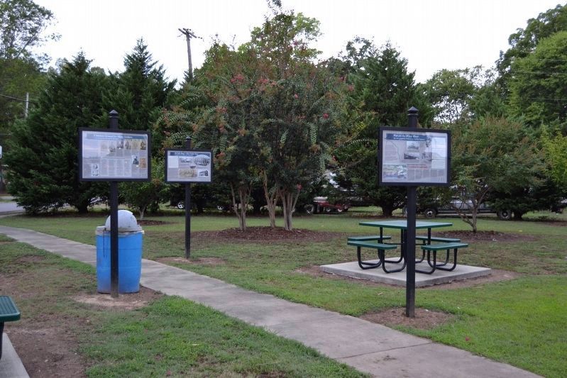
More about this marker. The marker is one of five Civil War interpretive signs in Rhodes Park; there are two other Civil War interpretive signs in DeValls Bluff.
Also see . . .
1. DeValls Bluff (Prairie County). From The Arkansas Encyclopedia of History & Culture. Includes information on De Valls Bluff’s role in the Civil War. (Submitted on August 10, 2016.)
2. DeValls Bluff. Arkansas Department of Parks, Heritage, and Tourism website entry (Submitted on March 4, 2024, by Larry Gertner of New York, New York.)
Additional commentary.
1. Marker Sponsors
The following is written at the lower right corner of the marker: “This project is supported in part by a grant from the Arkansas Humanities Council and the Department of Arkansas Heritage. Other sponsors are the Arkansas Sesquicentennial Commission, the City of DeValls Bluff and the Bill & Sharon Arnold Family Foundation.”
— Submitted August 10, 2016.
Credits. This page was last revised on March 4, 2024. It was originally submitted on August 10, 2016, by Duane Hall of Abilene, Texas. This page has been viewed 677 times since then and 77 times this year. Photos: 1, 2, 3. submitted on August 10, 2016, by Duane Hall of Abilene, Texas.


