3 entries match your criteria.
Related Historical Markers
See other markers tracing the Cherokee Path
By Brian Scott, November 28, 2008
The Cherokee Path Marker - Reverse
SHOWN IN SOURCE-SPECIFIED ORDER
| On Cherokee Foothills Scenic Highway (SC Highway 11). |
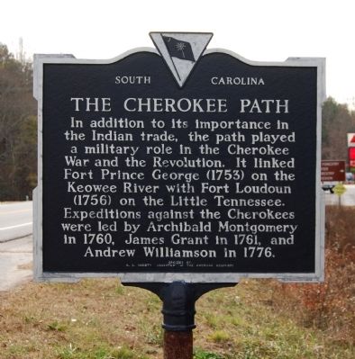
| | [Front Side]:
The main trading path to the Cherokee Nation paralleled the route of Highway 11 for several miles at this point. This section of the path was used by travelers going from Keowee, the main Lower Town of the Cherokees, across . . . — — Map (db m14383) HM |
| On East Main Street (Georgia Route 17) at Red Hollow Road, on the left when traveling north on East Main Street. |
| | Winding along a ridge from the mouth of Broad River to the head at Tugalo, RED HOLLOW ROAD evolved from the noted trace, UPPER CHEROKEE PATH, and became part of a complex pioneer road system.
In 1736-1737, Oglethorpe had River Road laid out . . . — — Map (db m14564) HM |
| On Charleston Highway (U.S. 176/321) near Between Dixiana Road and Old Dunbar Road, on the right when traveling north. |
| | In 1718, at a site 2.7 miles east, near the place where the Cherokee Path crossed Congaree Creek, the first frontier outpost in central South Carolina was established under the command of Captain Charles Russell. The fort was abandoned in 1722, but . . . — — Map (db m21711) HM |
Jun. 16, 2024