On SC Road 33-7, on the right when traveling north.
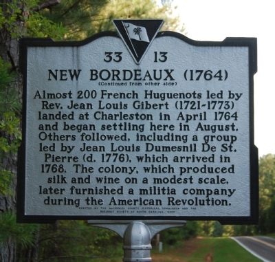
The town of New Bordeaux, the last of seven French Huguenot colonies founded in colonial S.C. and the only one in the upcountry, was established 1 mi. E in 1764. After Protestants fleeing religious persecution in France petitioned the British . . . — — Map (db m51286) HM
On Savannah River Scenic Byway (State Highway 28) at Barksdale Ferry Road (County Route S-33-61), on the left when traveling west on Savannah River Scenic Byway.
Badwell
Three miles west is the site of "Badwell," home of James Louis Petigru (1789-1863), leader of opposition to secession in South Carolina, outstanding Charleston lawyer, and S.C. Attorney General. He studied at Willington Academy under . . . — — Map (db m11456) HM
On State Highway 28 at Old Charleston Road (Local Road 38), on the left when traveling south on State Highway 28.
About four miles southeast is the site of the American Revolutionary Battle of Long Cane. On December 12, 1780, Lieutenant Colonel Isaac Allen and a British force of 400-500 men defeated Colonel Elijah Clarke and 100 Americans, an advanced . . . — — Map (db m241074) HM
On North Mine Street, on the left when traveling south.
Dorn's Mill. Built ca. 1899, this steam-powered mill employed a milling process pioneered earlier by inventor Oliver Evans, which virtually eliminated manual labor. First known as the McCormick Enterprise Ginnery, the mill became the . . . — — Map (db m243241) HM
Near Mt. Carmel Road (State Highway 823) at State Highway 40. Reported missing.
Built ca. 1854 on a mill site in use since the 1770s, this large brick building on Little River was used for grinding corn, wheat, and other grains. A post office and various commercial enterprises operated near the mill during the 1800s. The . . . — — Map (db m18890) HM
On Mt. Carmel Road (State Highway 823) near Old Charleston Road. Reported missing.
Driven from the area at the start of the Cherokee War, settlers from Long Canes returned in the fall of 1760 and, under the protection of a party of Chickasaw Indians, reclaimed the land by building Fort Boone near here. — — Map (db m25200) HM
Three miles west is the site of an attack by Cherokee Indians upon settlers of Long Canes in the Cherokee War of 1759-1761. There on February 1, 1760, about 150 settlers, refugeeing to Augusta, were overtaken by 100 Cherokee warriors. . . . — — Map (db m11640) HM
On State Highway 81 at Morrah Bridge Road (County Route 39), on the left when traveling north on State Highway 81.
Cherry Hill
Three miles southwest is "Cherry Hill," site of the home of George McDuffie (1790-1851), orator of nullification, member of the U.S. House of Representatives and the U.S. Senate, Major General of the State Militia, and Governor of . . . — — Map (db m11461) HM