108 entries match your criteria. Entries 101 through 108 are listed.⊲ Previous 100
Missouri, The State Historical Society of Historical Markers
Markers of the State Historical Society of Missouri installed in every county by the State Historical Society and State Highway Commission from 1951 to 1961. Also includes markers installed in 1958 along the route of the Butterfield Overland Mail in Missouri.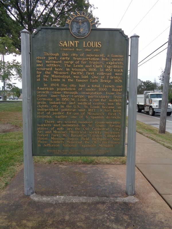
By Jason Voigt, October 10, 2019
Saint Louis Marker
| 101 ► Missouri, St. Louis County, Sappington — Saint Louis — |
| First city of the Trans-Mississippi West and second permanent settlement in Missouri. Founded, 1764, by the New Orleans Frenchman Laclede as a trading post to tap the rich fur resources of the Missouri Valley. Named for canonized Louis IX, French . . . — — Map (db m140858) HM | |||
| 102 ► Missouri, Ste. Genevieve County, Ste. Genevieve — Sainte Genevieve — |
| Oldest permanent settlement in Missouri founded ca. 1735 by Illinois French as river depot for lead and salt. Moved 3 miles to present site after 1785 flood. Named for the patroness sait of Paris. A vivid reminder of claims of France and Spain . . . — — Map (db m143474) HM | |||
| 103 ► Missouri, Sullivan County, Milan — Sullivan County — |
| Side 1 First called Highland, Sullivan County was formed, 1843. Fully organized in 1845, it was named for Revolutionary War Gen. John Sullivan. Comprising 654 sq. miles of high glacial prairie land, the county lies in territory ceded 1824, . . . — — Map (db m95702) HM | |||
| 104 ► Missouri, Vernon County, Nevada — Nevada — |
| Side A Financial center and shipping point, this prairie town was founded in 1855 as the seat of Vernon County, fertile farming and coal producing area. Col. D. C. Hunter, who laid out the town, named it for Nevada City, Calif. The county, . . . — — Map (db m44016) HM | |||
| 105 ► Missouri, Warren County, Warrenton — Daniel Boone — |
| Daniel Boone, universal symbol of the American frontier, was 65 when he came to Upper Louisiana, now Missouri, 1799. His wife Rebecca was 60. The Spanish lieutenant governor granted Boone 845 acres nearby here on Femme Osage Creek. Boone did . . . — — Map (db m42564) HM | |||
| 106 ► Missouri, Webster County, Marshfield — Webster County — |
| Webster County, organized March 3, 1855, encompasses 590 sq. miles of the highest extensive upland area of Missouri’s Ozarks. The judicial seat, Marshfield, lies 1490 feet above sea level, highest county seat in Mo. Pioneer legislator John F. . . . — — Map (db m99606) HM | |||
| 107 ► Missouri, Worth County, Grant City — Worth County — |
| [side 1] The last of Missouri's 114 counties to be formed, Worth was organized in Feb., 1861, 6 months and 39 years after Missouri was admitted into the Union, Aug., 1821, with 25 counties. Encompassing 267 sq. miles of . . . — — Map (db m179674) HM | |||
| 108 ► Missouri, Wright County, Hartville — Wright County — |
| Wright County, in the Ozark Highland of Missouri, lies in a region ceded the U.S. by the Osage Indians in 1808. The first white settlers, mainly from Tennessee, came in the 1830’s. The county, named for Senator Silas Wright of N.Y., was organized in . . . — — Map (db m99290) HM | |||
108 entries matched your criteria. Entries 101 through 108 are listed above. ⊲ Previous 100