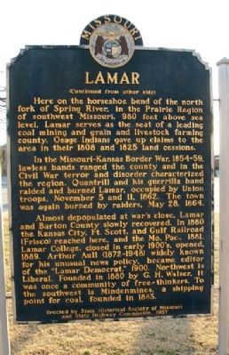
On Gulf Street at 11th Street West, on the right when traveling north on Gulf Street.
Side A
Lamar is distinguished as the birthplace of Harry S. Truman, the 33rd President of the United States. The son of John Anderson Truman and Martha Ellen (Young) Truman, he was born May 8, 1884. The family moved to Harrisonville in Cass . . . — — Map (db m42286) HM
On Broadway at 10th Street, on the right when traveling south on Broadway.
On October 1st, 1910, this cannon and original memorial presented to Barton County, Missouri by the members of McCook Post No. 34 G.A.R. Department of Missouri. It was dedicated to the memory of the soldiers and sailors of the Civil War 1861-1865. . . . — — Map (db m42302) WM
Near Marth Road (County Road 1002) near Cooper Road (County Road 5001).
In the 1860s, the vast, rolling tallgrass prairies of the Osage Plains stretched for miles. Maintained by periodic fires for approximately 5,000 years before European settlement, prairie once covered approximately 78 percent of Bates County, Mo. . . . — — Map (db m60613) HM
On Morgan Street near Main Street (U.S. 40), on the left when traveling east.
David Barton was born December 14, 1783, near Greeneville, North Carolina (now Tennessee). He came to the then-Louisiana Territory in 1809. Though Barton had some legal training, his first job was teaching in St. Charles. When the Missouri . . . — — Map (db m46019) HM
On Kansas Avenue just north of Lakin Avenue, on the left when traveling north.
In the 1800s, the Santa Fe Trail was the Interstate-70 of the American West, and Conestoga wagons were its freight-hauling tractor trailers. Between 1822 and 1879, the trail was a commercial thoroughfare between Missouri and Santa Fe, guiding . . . — — Map (db m302743) HM
Thin black lines indicate changes in relevance. Between each pair of lines entries are ordered geographically but all have the same relevance.
* Inflectional forms of words are their plurals, singulars, and possessives as well as gramatical tenses and similar variations.