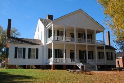
On Brattonsville Road 0.1 miles north of Percival Road, on the right when traveling south. Reported missing.
The Homestead was built between 1823 and 1826 for Dr. John Simpson Bratton and his wife Harriet Rainey Bratton, the second generation of the Bratton family to live at Brattonsville. Bricks for the chimneys were made on the plantation. The two . . . — — Map (db m272030) HM
On Carlisle Street just west of South Main Street (U.S. 60), on the right when traveling west.
[front side] Twenty-two Kentucky courthouses were burned during Civil War, nineteen in last fifteen months: twelve by Confederates, eight by guerrillas, two by Union accident. See map on reverse side. The courthouse at Marion was burned by . . . — — Map (db m79179) HM
On County Road N80NE at Road E280N, on the right when traveling south on County Road N80NE.
Caroline and her four children escaped Kentucky slave owner October 31, 1847; they crossed Ohio River near Madison. After passing near here, Fugit Township black and white residents hid family close to Clarksburg. While hidden, family seized . . . — — Map (db m44743) HM
Near Ohio River Scenic Byway (Ohio Route 124) south of New Portland Road, on the right when traveling south.
Closing the Net
Frustrated by multiple failed attempts to overtake
Morgan in Kentucky, Major General Ambrose Burnside
dispatched Union Brigadier General Edward Hobson
and 2,500 Union soldiers on July 6 with specific
orders to intercept . . . — — Map (db m108368) HM
On Old Buncombe Road at Jones Ford Road, on the left when traveling east on Old Buncombe Road.
[Front]:
A post office was established in 1809 at Cross Keys, S.C. In 1812-1814, Barrum Bobo erected this house at the intersection of the Piedmont Stage Road and the Old Buncombe Road. During the ante-bellum period, it was the center of . . . — — Map (db m13390) HM
On Maynardville Highway (Tennessee Route 33/61) at Spring Strret, on the right when traveling east on Maynardville Highway.
The Civil War made civilian life in Union County difficult and dangerous. Most residents opposed secession and were staunch Unionists. men joined such Federal regiments as the 1st Tennessee Infantry and the 2nd and 9th Tennessee Cavalry. Others . . . — — Map (db m100481) HM
Near North Water Street north of 1st Street, on the left when traveling north.
During the 1940's a thriving nightclub and gambling industry developed in Henderson County, patronized not only by local citizens but also by workers from Evansville's war factories and soldiers from nearby Camp Breckinridge. By 1950 it was said . . . — — Map (db m121697) HM
On Norris Freeway (U.S. 441) 0.1 miles south of Clear Creek Road, on the left when traveling south.
Divided loyalties in Anderson County, as elsewhere in East Tennessee, often erupted in violence. It was commonplace for guerillas on both sides to raid farms and capture opposing sympathizers. In the county seat of Clinton, Confederates . . . — — Map (db m119021) HM
Thin black lines indicate changes in relevance. Between each pair of lines entries are ordered geographically but all have the same relevance.
* Inflectional forms of words are their plurals, singulars, and possessives as well as gramatical tenses and similar variations.