On Mt. Lebanon Road, 0.5 miles west of Old State Road (U.S. 176), on the right when traveling west.
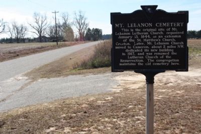
This is the original site of Mt. Lebanon Lutheran Church, organized January 13, 1844, as an extension of the St. Matthew's Church, Creston. Later, Mt. Lebanon Church moved to Cameron about 2 miles NW, dedicated its new building in 1917, and was . . . — — Map (db m27239) HM
On Cameron Road (State Highway 33) near Nate's Store Road (State Highway 9-27), on the right when traveling east.
Shady Grove Methodist Church was an outgrowth of Tabernacle Church, the parent Methodist body of this area. It was built in the early 1800s on land of Adam Holman, has a framework of hewn logs held together with wooden pegs, and has been . . . — — Map (db m26201) HM
On South Railroad Avenue (State Highway 9-48) at Dantzier Street, on the right when traveling south on South Railroad Avenue.
First settled in 1704, this region by 1733 included Amelia and lower Saxe Gotha townships. In 1765 much of it was made part of the new St. Matthew's Parish and was so named until 1865. Efforts in 1890 and 1896 led to an act signed on Feb. 14, 1908 . . . — — Map (db m26057) HM
On Waterspring Road (State Highway 38-142) near Lime Kiln Road, on the left when traveling east.
This cemetery was the burial site
of the Miller family from the early
1800s. The remaining stones erected
in 1836, are to John Miller (1750-1854),
soldier of the revolution; his wife,
Margaret Ott Miller; and their son,
John Miller Jr. Their . . . — — Map (db m25184) HM