Near Dunker Church Road / Old Hagerstown Pike, on the right when traveling south.
Maryland Baltimore Battery Jackson's Division C.S.A. The battery, under the command of Capt. J.B. Brockenbrough, occupied a position near this marker at daybreak, and opened the battle on the Confederate side. The monument to the Maryland troops . . . — — Map (db m6270) HM
On Smoketown Road at Mummas Lane, on the left when traveling south on Smoketown Road.
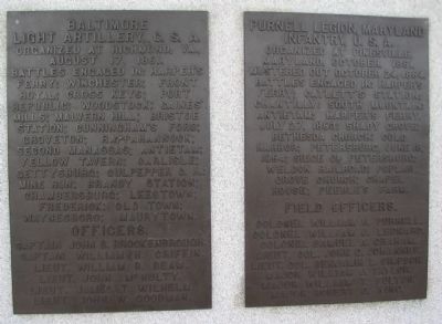
Maryland Battery A 1st MD Light Artillery 1st Slocum's Division 6th Franklin's Corps The battery under the command of Capt. John W. Wolcott occupied a line 100 feet in rear of this marker and facing Dunkard Church. Loss 1 killed, 11 wounded. The . . . — — Map (db m6035) HM
On Cornfield Avenue, on the right when traveling west.
Maryland Battery B. 1st Md. Light Artillery 2nd (Smiths) Division 6th (Franklins) Corps The battery under the command of Lieut. Theodore J. Vanneman. Occupied a position on the edge of the East Woods, 240 yards north from this marker the . . . — — Map (db m5720) HM
Near Old Burnside Bridge Road, on the left when traveling east.
Maryland 2nd Md Infantry At 9:30 a.m. advanced on the stone bridge, defended by Toombs' Brigade and two batt- eries on high ground beyond. Charged to within 100 yards of the bridge when, checked by the severity of the enemy's fire it took . . . — — Map (db m6463) HM
On Dunker Church Road / Old Hagerstown Pike, on the right when traveling north.
Maryland 3rd Md. Infantry. 2nd Stainbrook's Brigade. 2nd Greene's Division. 12th Mansfield's Corps. Advanced to the corner of the Dunkard Church, in front of this Marker. Loss, 4 killed, 25 wounded. The monument to the Maryland troops is near . . . — — Map (db m6857) HM
On Richardson Avenue, on the left when traveling east.
Maryland 5th Md Infantry 3rd Max Weber's Brigade. 3rd French's Division. 2nd Sumner's Corps. Advanced to the knoll above the Bloody Lane. 300 feet in the rear of of this marker. Loss. 43 killed 123 wounded. The monument to the Maryland troops . . . — — Map (db m5487) HM
Near Richardson Avenue, on the left when traveling east.
Erected by the survivors of Company A & I to the memory of our fallen comrads who fell on this spot September 17, 1862. ———— This stone marks the extreme advance of Weber's Brigade French's Div. 2nd Army Corps . . . — — Map (db m17622) HM