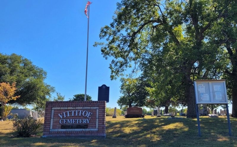
On Andy Thomas Road 0.7 miles south of State Road 11, on the left when traveling south.
This graveyard was begun as a family burial plot by Samuel and Ellen Vittitoe, who settled on land surrounding this site in 1852. Their son, Frank, probably was the first to be buried here sometime before the outbreak of the Civil War, although his . . . — — Map (db m256517) HM
On Lincoln Park Road (Kentucky Route 528) north of Mudd & Kelly Lane, on the right when traveling north.
Built in 1797, the Mordecai Lincoln House is one of two structures in Kentucky, of those formerly owned by members of President Lincoln's family, which still stands largely intact on its original site. Mordecai Lincoln purchased 400 acres for 100 . . . — — Map (db m250702) HM
On Pettit Parkway (U.S. 69) at West Grand Street, on the right when traveling north on Pettit Parkway.
Early settlers in this part of Grayson County established communities at Orangeville (4 mi. E), Pilot Grove (4 mi. S), and Kentucky Town (3 mi. W). In 1878, after the Missouri, Kansas, and Texas (MKT) Railroad built a line southeast from Denison to . . . — — Map (db m256520) HM
On West Pine Street at South Sears Street, on the right when traveling east on West Pine Street.
In 1855, men in Kentucky Town organized a Masonic lodge, receiving their charter the following year as the Kentucky Town Masonic Lodge No. 167. More than 20 years later, in 1878, the Missouri, Kansas & Texas Railroad bypassed Kentucky Town, running . . . — — Map (db m256539) HM
On Falls of Rough Road (State Road 79) at Robinson Road, on the right when traveling south on Falls of Rough Road.
George Eskridge, born in Virginia in 1763, served in Revolutionary War, having enlisted in the Virginia Continental line at an early age. Eskridge came to Kentucky and settled in Grayson County, circa 1811. Built a log house at Falls of Rough River . . . — — Map (db m162247) HM
On S Ferguson Pkwy (County Road 367) 0.1 miles south of W White Street, on the right when traveling south.
In the 1850s, North Texas attracted settlers from border states like Kentucky with the promise of inexpensive land for farming and stock raising. One such man was Dr. William Dixon Lair (1814-1887), a pioneer physician, former Kentucky state . . . — — Map (db m309928) HM
On North 3rd Street, on the right when traveling west.
Born in Marlboro, Mass., to Micah and Susanna Dennison (Frost) Sherman, Sidney Sherman (1805-1873) lived in Boston, New York City, and Cincinnati before settling in Newport, Ky. There he married Catherine Isabel Cox (1815-1865) in 1835; the couple . . . — — Map (db m290049) HM
On Grayson Springs Road (Kentucky Route 1214) west of Route 88, on the right when traveling east.
Site of famous spa started in mid-1820's, owned by M. P. Clarkson, and known for healing powers of its mineral water springs. Resort reached its height in 1900 under ownership of Mercke brothers. Also home of St. Augustine's, first Roman Catholic . . . — — Map (db m290228) HM
On Pine Street at North State Line Avenue, on the left when traveling south on Pine Street.
Worshiped in 1831 at McKinney's Landing, where the McKinney family and a small group of neighbors met together for informal services. During the winter of 1841-1842, a traveling preacher from Illinois, G. Gates, organized the congregation into a . . . — — Map (db m286697) HM
On West Lamar Street at South Woods Street on West Lamar Street.
Born near Fair Dealing, Kentucky, Mita Holsapple moved with her family to Sherman as a child and graduated from Mary Nash College. Wed to Hugh E. Hall in 1919, she organized the first Camp Fire Girls group in Sherman two years later. For the next 44 . . . — — Map (db m256720) HM
On Front Street (County Route 300B) at Austin Street (Route 300E), on the left when traveling east on Front Street.
During a brief and troubled time in her life, Carry Amelia Moore Nation (1846-1911) operated the "Old Columbia Hotel" on this site about 1880. She later achieved fame as a hatchet-wielding crusader against the use of alcoholic drink and tobacco. . . . — — Map (db m89328) HM
On Houston Street (State Highway 56) at Travis Street, on the left when traveling west on Houston Street.
Peter Wagener Grayson was born in 1788 in Bardstown, Virginia (later part of Kentucky) to Benjamin and Caroline (Taylor) Grayson, members of a politically prominent family. He served in the War of 1812 and worked in Louisville as an attorney, . . . — — Map (db m294308) HM
On State Street (U.S. 89) at Muddy Creek Road, on the left when traveling north on State Street.
Settlement of Long Valley and Mt. Carmel
The first written account of the exploration of Long Valley was given by John D. Lee in 1852. Coming from Parowan, the explorers were under the direction of Bishop John R. Smith. James Lewis kept the . . . — — Map (db m40584) HM
Thin black lines indicate changes in relevance. Between each pair of lines entries are ordered geographically but all have the same relevance.
* Inflectional forms of words are their plurals, singulars, and possessives as well as gramatical tenses and similar variations.