THE HISTORICAL
MARKER DATABASE
“Bite-Size Bits of Local, National, and Global History”


15 entries match your criteria.  


Ireland, Dublin City Council Commemorative Plaques Historical Markers

Per its website, the medallion plaques facilitate the formal commemoration of people, organisations, and events that have made a unique and significant contribution to the life or history of Dublin through outstanding achievement, distinctive service or significant community contribution.
 
By Ian Lefkowitz, May 18, 2026
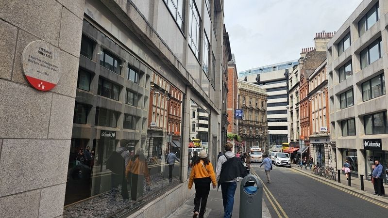
Fireman John Kite Marker
1 ► Ireland, Leinster, County Dublin, Dublin — Fireman John Kite —
On Trinity Street at Saint Andrew's Street, on the left when traveling north on Trinity Street.
[Irish:] A fuair bás ar dualgas anseo [English:] Died here in the line of duty 20.3.1884 — — Map (db m307100) HM
2 ► Ireland, Leinster, County Dublin, Dublin — Jane Lady Wilde / ‘Speranza’ — 1821–1896 —
On 1 Merrion Square North at Merrion Square West, on the left when traveling west on 1 Merrion Square North.
[Gaeilge:] File, Scríbhneoir, Gníomhaí A chónaigh anseo [English:] Poet, Writer, Activist Lived here — — Map (db m307556) HM
3 ► Ireland, Leinster, County Dublin, Dublin — Samuel Little Hardy (FRCSI) — 1815–1868 —
On Merrion Square North east of Merrion Square West, on the left when traveling west.
[Gaeilge:] Lia agus Cnáimhseoir a chonaigh anseo [English:] Physician and Obstetrician lived here — — Map (db m307557) HM
4 ► Ireland, Leinster, County Dublin, Dublin — Violet Gibson — 1876–1956 —
Near Merrion Square North west of Merrion Square East, on the left when traveling east.
[Gaeilge:] Frith-Fhaisisteach A chónaigh anseo [English:] Anti-Fascist Lived here — — Map (db m307630) HM
5 ► Ireland, Leinster, County Dublin, Dublin, Dublin's Docklands — S.S. Adela —
On Sir John Rogerson’s Quay just east of Creighton Street, on the left when traveling east.
Sunk by U-boat with twenty-four lives lost 27th December 1917 Chuir U-bhád go tóin poill í Cailleadh ceithre dhuine is fiche 27 NoHaig 1917 — — Map (db m269684) HM WM
6 ► Ireland, Leinster, County Dublin, Dublin, North City — Anna Parnell — 1852 - 1911 —
On O'Connell Street Upper just south of Parnell Street, on the left when traveling north.
Ladies Land League WORKED HERE Conradh Talún na mBan, À D'OIBRIGH ANSEO — — Map (db m269749) HM
7 ► Ireland, Leinster, County Dublin, Dublin, North City — Devlin's Pub — 1919 - 1921 — Cogadh na Saoirse [Irish War of Independence] —
On Parnell Street at Moore Lane, on the left when traveling west on Parnell Street.
GHQ Intelligence met here Chas CCG Faiséise le chéile anseo — — Map (db m269762) HM
8 ► Ireland, Leinster, County Dublin, Dublin, North City — Ireland's First Radio Broadcast — Rinneadh an Chéad Chraoladh Raidió Éireannach — The Easter Rising 1916 / Éirí amach na cásca 1916 —
On Abbey Street Lower at O'Connell Street Upper, on the right when traveling east on Abbey Street Lower.
Was transmitted from here / Ón áit seo 25.04.1916 — — Map (db m240451) HM
Paid Advertisement
9 ► Ireland, Leinster, County Dublin, Dublin, North City — Royal Hibernian Academy of Arts — Original Home / Baile Bunaidh — 1826 - 1916 —
On Abbey Street Lower just east of O'Connell Street Upper, on the right when traveling east.
[Title is text] — — Map (db m240449) HM
10 ► Ireland, Leinster, County Dublin, Dublin, North City — The Beatles —
On Middle Abbey Street 0.2 kilometers west of O'Connell Street Upper, on the right when traveling west.
. . . — — Map (db m240685) HM
11 ► Ireland, Leinster, County Dublin, Dublin, Penthouse — Hanna Sheehy Skeffington —
On Castle Street at Ship Street Great, on the right when traveling north on Castle Street.
[Gaeilge:] Sufraigéid A rinne smidiríní de na fuinneoga seo 13 Meitheamh 1912 [English:] Suffragette Smashed these windows 13th June 1912 — — Map (db m307813) HM
12 ► Ireland, Leinster, County Dublin, Dublin, Smithfield — Four Courts Garrison / Garastún na gCiethre Cúirteanna — The Easter Rising 1916 / Éirí amach na cásca 1916 — We Remember / Is cuimhin linn —
On Church Street (National Route 1) at Church Terrace, on the left when traveling north on Church Street.
[Title is text] — — Map (db m240413) WM
13 ► Ireland, Leinster, County Dublin, Dublin, Temple Bar — Edward Walsh — 1873 – 1916 —
On Parliament Street north of Dame Street, on the left when traveling south.
[Gaeilge:] Ball den Hibernian Rifles Éag-ghonta sa láthair seo [English:] Member of the Hibernian Rifles Mortally wounded here [Gaeilge:] Éirí Amach na Cásca 1916 — — Map (db m304672) HM
14 ► Ireland, Leinster, County Dublin, Dublin, Temple Bar — Frederick Douglass —
On Eustace Street just north of Dame Street (Route R137), on the left when traveling north.
Anti-Slavery Leader Spoke Here 1845 Cennaire Frith-Sclábhaíochta A Labhair Anseo 1845 — — Map (db m240588) HM
15 ► Ireland, Leinster, Dublin, Temple Bar — Hirschfeld Centre — 1979 – 1987 —
On Fownes Street Lower south of Temple Bar, on the left when traveling south.
. . . — — Map (db m304610) HM
 
 
CeraNet Cloud Computing sponsors the Historical Marker Database.
This website earns income from purchases you make after using our links to Amazon.com. We appreciate your support.
Paid Advertisement
Nov. 11, 2026
