4 entries match your criteria.
Related Historical Markers
To better understand the relationship, study each marker in the order shown.
By Brian Scott, January 17, 2009
Due West Marker -
Looking Across Main Street
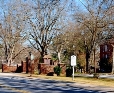
Erskine College Entrance (Left)
SHOWN IN SOURCE-SPECIFIED ORDER
| On North Main Street (State Highway 184) at College Street (State Highway 20), on the left when traveling south on North Main Street. |
| |
As early as 1765 the site 6 miles NW known to the Indians as Yellow Water, where the Keowee Path crossed the Cherokee line, was called DeWitt's Corner. In 1777 a treaty between S.C. and the Cherokee Indians was signed there. The present town was . . . — — Map (db m10602) HM |
| On McCarter Drive (State Highway 418) west of Interstate 385, on the right when traveling west. |
| |
[Front]:
In 1766-67 S.C. & N.C. negotiated with the Cherokee to establish a boundary between Indian land to the west and new settlement to the east. This north-south line ran past this point to N.C. and on to Va. In S.C. it ran north . . . — — Map (db m10002) HM |
| On South Highway 14 (State Highway 14), on the left when traveling north. |
| |
[Front]:
In 1766-67 S.C. & N.C. negotiated with the Cherokee to establish a boundary between Indian land to the west and new settlement to the east. This north-south line ran past this point to N.C. and on to Va. In S.C. it ran north . . . — — Map (db m8446) HM |
| | [Front Side]:
The Cherokee sided with the British during the American Revolution, and in 1776 Maj. Andrew Williamson's S.C. militia destroyed their "Lower Towns" in what is now S.C. He then cooperated with the N.C. militia in expeditions . . . — — Map (db m14351) HM |
Jun. 18, 2024