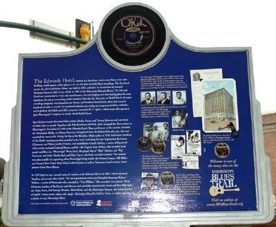
On West Capitol Street at South Mill Street, on the right when traveling east on West Capitol Street.
Constructed in 1923 and renamed the King Edward Hotel in 1954, the Edwards Hotel was the site of temporary studios set up by OKeh Records in 1930 and the American Record Corporation in 1935 to record blues artists Bo Carter, Robert Wilkins, Joe . . . — — Map (db m49680) HM
On Farm to Market Road 1415 at County Road 1036, on the right when traveling south on Road 1415.
Named for Jim and Winnie Shankle, known as first Newton County Blacks to buy land and become local leaders after gaining freedom by emancipation.
Both were born in slavery: Jim in 1811, Winnie in 1814. After Winnie and her three children were . . . — — Map (db m290446) HM
Near Good Hope Church Road 1.6 miles south of State Route 503, on the left when traveling south.
Lynching in America
Over 6,500 African Americans were victims of racial terror lynching in the United
States between 1865 and 1950. Following the Emancipation Proclamation and the Civil
War, many white Americans remained committed to . . . — — Map (db m234969) HM
On Floyd Street 0 miles east of Church Street (Georgia Route 36), on the right when traveling west.
Here was located the office in which L.Q.C. Lamar, Statesman and Jurist, practiced law at two intervals from 1847 to 1854, thence moving to Macon and Mississippi. His family located at Covington after his father's death in 1834, and at nearby Oxford . . . — — Map (db m289766) HM
In 1852 wealthy Mississippi sawmill owner David Robert Wingate moved his family to a large cotton plantation in Newton County. During the Civil War (1861-65), he donated lumber from his Sabine Pass sawmill to build Fort Sabine and other posts. . . . — — Map (db m141141) HM
On South Main Street at Cedar Street, on the right when traveling north on South Main Street.
Newton County has a dual claim to blues fame, first as the birthplace of several historical figures and later as the site of an important blues event, the Chunky Rhythm & Blues Festival. Newton County natives include record businessman H.C. Speir . . . — — Map (db m141357) HM
On Court Street (State Highway 7) at Stone Street (State Highway 7), on the right when traveling east on Court Street.
Civil War in Newton County Several military actions took place in Newton
County during the Civil War. On Jan. 10, 1863, Union
troops attacked and destroyed a large saltpeter
works on the Buffalo River. Skirmishes were fought
June 14 and Nov. . . . — — Map (db m225345) HM
On Farm to Market Road 1414 0.4 miles south of County Road 2069, on the left when traveling south.
Brothers Sebern (1809-1865), Allen (1814-1887) and John Woods and their families were living in Yalobusha County, Mississippi, in 1840. They traveled to the Republic of Texas with their parents, John (1785-1863) and Mary (b. 1790) Woods, in the . . . — — Map (db m290449) HM
On State Highway 87 at County Highway 1100, on the right when traveling south on State Highway 87.
Early 19th Century trade routes across the Sabine River were few, and served all travelers and traders. The Beef Road, which replaced earlier “Zavala Road”, was an important route by 1840, crossing this area. Named for cattle trade, it . . . — — Map (db m107172) HM
Near Stallings Street Northwest at Hunter Avenue Northwest, on the right when traveling west.
Can you imagine living and growing up at the jail? When Newton County completed its new jail in 1901, the front half had been designed as a home for the sheriff or a staff member and his family, an arrangement typical of this period. The sheriff was . . . — — Map (db m197740) HM
Thin black lines indicate changes in relevance. Between each pair of lines entries are ordered geographically but all have the same relevance.
* Inflectional forms of words are their plurals, singulars, and possessives as well as gramatical tenses and similar variations.