Marker Logo HMdb.org THE HISTORICAL
MARKER DATABASE
“Bite-Size Bits of Local, National, and Global History”


7 entries match your criteria.  


Related Historical Markers

It is all of the Eastern Kentucky Railway Historical Markers
 
E.K. Railway Marker image, Touch for more information
By Don Morfe, April 15, 2014
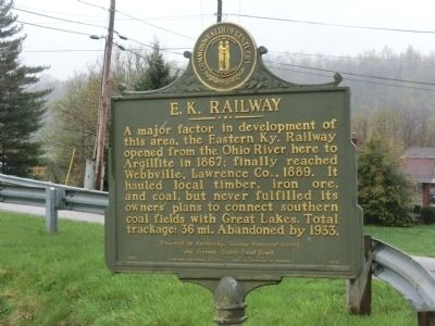
E.K. Railway Marker
SHOWN IN SOURCE-SPECIFIED ORDER
1 Kentucky, Greenup County, Greenup — 1178 — E. K. Railway
On North 5th Street.
2 Kentucky, Greenup County, Argillite — 1978 — E. K. Railway
On Kentucky Route 1 at Kentucky Route 207, on the right when traveling north on State Route 1.
3 Kentucky, Greenup County, Hunnewell — 2163 — E. K. Railway – Hunnewell
On Kentucky Route 207 north of Tunnel Branch Road (Kentucky Route 3306), on the left when traveling south.
4 Kentucky, Carter County, Grayson — 1596 — Eastern Kentucky Railway
On Carol Malone Boulevard (Kentucky Route 7) just north of East 2nd Street, on the right when traveling north.
5 Kentucky, Carter County, Hitchins — 2246 — Eastern Kentucky RailwayHitchins
On Route 773, 0.1 miles west of Hitchens Rd (Kentucky Route 1), on the left when traveling west.
6 Kentucky, Carter County, Willard — 2301 — Eastern Kentucky RailwayWillard
On Kentucky Route 1 just north of Kentucky Route 1496, on the left when traveling south.
7 Kentucky, Lawrence County, Webbville — 2056 — Eastern Kentucky Railway
On Kentucky Route 201 just west of Kentucky Route 1, on the right when traveling west.
 
 
CeraNet Cloud Computing sponsors the Historical Marker Database.
This website earns income from purchases you make after using our links to Amazon.com. We appreciate your support.
Paid Advertisement
Jun. 15, 2024