5 entries match your criteria.
Related Historical Markers
To better understand the relationship, study each marker in the order shown.
By Dale K. Benington, August 9, 2010
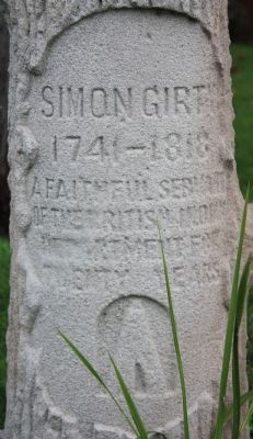
Simon Girty's Gravestone
SHOWN IN SOURCE-SPECIFIED ORDER
| On Front Street South (Provincial Highway 20) south of Bingham Road, on the left when traveling south. |
| On County Route 39, 2.5 miles north of Ohio Route 274, on the right when traveling south. |
| On West Spring Street (Ohio Route 703) east of South Wayne Street. |
| On Herzing Street, 0.2 miles east of South Main Street (Ohio Route 66), on the left when traveling east. |
| On North Front Street (Alternate U.S. 322) at Fort Hunter Road, on the right when traveling south on North Front Street. |
Jun. 2, 2024