6 entries match your criteria.
Related Historical Markers
Virtual tour of the the Piper Farm by markers.
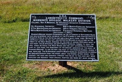
By Brian Scott, September 19, 2015
Longstreet's Command Marker
SHOWN IN SOURCE-SPECIFIED ORDER
| On Hagerstown Pike (State Highway 65) at Richardson Avenue, on the right when traveling north on Hagerstown Pike. |
| On Hagerstown Pike (State Highway 65) at Richardson Avenue, on the right when traveling north on Hagerstown Pike. |
| On Bloody Lane west of Maryland Highway 65, on the right when traveling east. |
| On Hagerstown Pike (State Highway 65) at Richardson Avenue, on the right when traveling north on Hagerstown Pike. |
| On Sharpsburg Pike (Maryland Route 65) at Bloody Lane, on the right when traveling north on Sharpsburg Pike. |
| On Sharpsburg Pike (Maryland Route 65) 0.2 miles south of Bloody Lane, on the right when traveling north. |
Nov. 11, 2026
