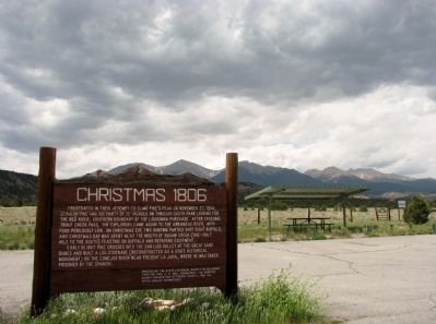
On U.S. 285 5 miles north of U.S. 50, on the left when traveling north.
Frustrated in their attempt to climb Pike’s Peak on November 27, 1806, Zebulon Pike and his party of 15 trudged on through South Park looking for the Red River, southern boundary of the Louisiana Purchase. After crossing Trout Creek Pass, the . . . — — Map (db m127876) HM
On U.S. 285 5 miles north of U.S. 50, on the left when traveling north.
With the acquisition of the Louisiana Purchase in 1803, the United States had extensive new lands to explore. In search of a new border While Lewis and Clark engaged in their famous “Voyage of Discovery” along the Missouri River (1803-1806), . . . — — Map (db m293486) HM
On East Main Street (State Highway 96) just east of Fleetwood Street, on the right when traveling east.
The Arkansas River, South Park, Grape Creek, the wet mountain valley and crossed the Sangre de Cristo Mountains in the winter of 1806-1807. Baroney Vasquez • Dr. John Robinson • Sgt. William Meek • Cpl. Jeremiah Jackson • John Brown • Jacob Carter . . . — — Map (db m282098) HM