3 entries match your criteria.
Related Historical Markers
To better understand the relationship, study each marker in the order shown.
By Dale K. Benington, July 16, 2009
State Line Marker
SHOWN IN SOURCE-SPECIFIED ORDER
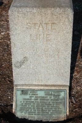
| | [Front of Marker]
STATE LINE
Surveyed By
S. S. Gannet
Geographer
United States
Geological Survey
1915
[Ohio Side of Marker]
OHIO
Frank B. Willis
Governor
- - - - -
Erected by Authority of
The . . . — — Map (db m197401) HM |
| | Michigan troops made heir headquarters here during the bloodless Toledo "war" in 1835.
Intense rivalry between the settlers of the two states fanned a controversy near flame. Original U. S. surveys had put in Monroe County the mouth of the . . . — — Map (db m21010) HM |
| | The Ohio Michigan Boundary War. The Northwest Ordinance of 1787 defined the boundary of the northern and southern tier of states to be carved out of the Northwest Territory, as a line drawn east from the southernmost tip of Lake Michigan until . . . — — Map (db m21009) HM |
May. 11, 2024