THE HISTORICAL
MARKER DATABASE
“Bite-Size Bits of Local, National, and Global History”


5 entries match your criteria.  


Related Historical Markers

To better understand the relationship, study each marker in the order shown.
 
By Bill Coughlin, April 14, 2009
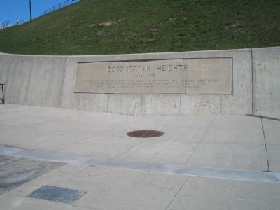
Marker at Dorchester Heights Nat'l Historic Site
SHOWN IN SOURCE-SPECIFIED ORDER
1 ► Massachusetts, Suffolk County, Boston, South Boston — Dorchester Heights — March 1776 —
Near Thomas Park at Pacific Street, on the left when traveling west.
As the final act of an eleven month siege, the Continental Army occupied these heights and forced the evacuation of British troops from Boston on March 17, 1776 – General George Washington’s first victory in the American Revolution. — — Map (db m295494) HM
2 ► Massachusetts, Suffolk County, Boston, South Boston — Dorchester Heights — National Historic Site —
On Thomas Park at Telegraph Street, in the median on Thomas Park.
These heights, commanding the harbor and town of Boston on the south, were seized and fortified by troops of the Continental Army and local militia under General John Thomas on the night of March 4, 1776. By this arduous night’s labor, and further . . . — — Map (db m295606) HM
3 ► Massachusetts, Suffolk County, Boston, South Boston — Nook Hill —
On B Street at Athens Street, on the right when traveling north on B Street.
This tablet is placed by the Society of Sons of the Revolution in the Commonwealth of Massachusetts March 16, 1900 to mark the site of Nook Hill. During the Siege of Boston by the American Forces under General Washington an attempt was made on . . . — — Map (db m295543) HM
4 ► Massachusetts, Suffolk County, Boston, Roxbury — Roxbury High Fort —
Near Fort Avenue.
On this eminence stood Roxbury High Fort a strong earth-work planned by Henry Knox and Josiah Waters and Erected by the American Army June 1775 - crowning the famous Roxbury lines of investment at the Siege of Boston — — Map (db m295492) WM
5 ► Massachusetts, Suffolk County, Boston, D Street / West Broadway — Many Forts, Many Uses — South Boston —
Near William J Day Boulevard east of Shore Road, on the right when traveling east.
Castle Island's strategic position alongside the narrow deepwater channel into Boston made it an ideal location to deter attacks. English colonists built the island's first fort in 1634. They used what was readily available—timber and mud. Each . . . — — Map (db m295604) HM


CeraNet Cloud Computing sponsors the Historical Marker Database.
This website earns income from purchases you make after using our links to Amazon.com. We appreciate your support.
Paid Advertisement
Oct. 9, 2026
