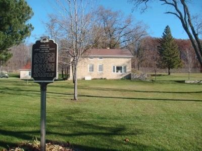
The home of James Duane Doty, oldest residence in Fond du Lac County, was built in 1839. Doty served as Federal Judge, Congressman, Governor of the Territory of Wisconsin and Superintendent of Indian Affairs. He was Governor of Utah when he died. . . . — — Map (db m38487) HM
It was future Wisconsin Governor James Doty who first envisioned a city on this site, after passing through the area and glimpsing its potential in 1829. In April 1836, Doty purchased land on this isthmus between two lakes. That November, he . . . — — Map (db m32909) HM
[Daughters of American Revolution seal]
This tablet marks the log cabin known as the Grand Loggery, built by Governor Doty, 2nd Territorial Governor of Wisconsin in 1847. It originally stood facing east on the west bank of the . . . — — Map (db m37727) HM
Madison changed with great speed in the 1830s: from Ho-Chunk home to war zone to capital city. Powerful forces were gathering against the Ho-Chunks. To gain more land, southwest Wisconsin lead miners pressured the U.S. government to remove the . . . — — Map (db m35314) HM
Dane County was created by the Wisconsin Territorial Legislature in 1836. Judge James Doty had convinced the Legislature to select Madison as the Capital and name the surrounding county in honor of Nathan Dane, a compiler of the Ordinance of 1787, . . . — — Map (db m37643) HM
Dane County was created by the Wisconsin Territorial Legislature in 1836. Judge James Doty had convinced the Legislature to select Madison as the Capital and name the surrounding county in honor of Nathan Dane, a compiler of the Ordinance of 1787, . . . — — Map (db m37611) HM
The story of Maiden Rock has several versions. One by Mary Eastman was published in 1849. She heard the story from an old Indian friend, Checkered Cloud, who firmly believed the event happened around 1700. A more romantic version in verse was . . . — — Map (db m10052) HM
In July, 1833, Lt. Alexander Center blazed a nearby oak, marking the 100-mile point of a military road he and James Doty were surveying. The Old Military Road, built from 1835 to 1837, connected Ft. Crawford at Prairie du Chien, Ft. Winnebago at . . . — — Map (db m36907) HM
Prehistoric woodland Indians built effigy mounds on the many glacial drumlins in this area, including those in Indian Mound Park. Later Winnebagoes lived along the shores of Lake Waubesa and the Yahara River. They ceded the land to the government in . . . — — Map (db m33761) HM
More than a thousand mounds once dotted the shores of Madison's lakes, so many that archaeologist Charles Brown favored the name Mound City for Madison. In the early 1900s, Brown found 160 mounds in 17 groups around Lake Monona. Native people . . . — — Map (db m35431) HM