Marker Logo HMdb.org THE HISTORICAL
MARKER DATABASE
“Bite-Size Bits of Local, National, and Global History”


9 entries match your criteria.  


Historical Markers in Megilot Council, West Bank

 
Qumran cave image, Touch for more information
By Erez Speiser, March 15, 2018
Qumran cave
1 Palestinian Territories, West Bank, Megilot Council, Kalya — Cave 1 / מערת 1
Near Route 90.
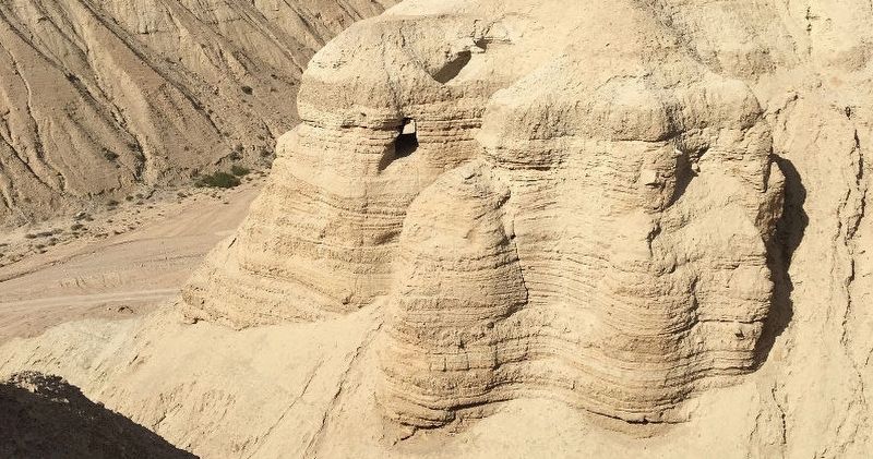
In 1947, three Bedouin shepherds discovered eight clay jars in this cave. One jar contained three scrolls: the complete Isaiah Scroll (written in popular version), the Community Rule (the rule book of the Qumran Sect), and the Habakkuk . . . Map (db m144168) HM
2 Palestinian Territories, West Bank, Megilot Council, Kalya — Kiln
Near National Route 90, 9 kilometers south of National Route 1, on the right when traveling south.
This Kiln was used to fire the pottery utensils manufactured in the potter's workshop.Map (db m132403) HM
3 Palestinian Territories, West Bank, Megilot Council, Kalya — Kitchenמטבח
Near National Route 90, 9 kilometers south of National Route 1, on the right when traveling south.
Scholars believe that this room was the common kitchen used by the inhabitants of Qumran.Map (db m132414) HM
4 Palestinian Territories, West Bank, Megilot Council, Kalya — Pottery Storeroom
Near National Route 90, 9 kilometers south of National Route 1, on the right when traveling south.
The utensils found here were broken in the earthquake of 31 B.C.E.Map (db m132410) HM
5 Palestinian Territories, West Bank, Megilot Council, Kalya — Ritual Bath
Near National Route 90, 9 kilometers south of National Route 1, on the right when traveling south.
They labor with great diligence till the fifth hour, after which they assemble themselves into one place, and when they have clothed themselves in white veils, they bath their bodies in cold water, and after this purification is over they meet . . . Map (db m132188) HM
6 Palestinian Territories, West Bank, Megilot Council, Kalya — The Bursar of the Congregation
Near National Route 90, 9 kilometers south of National Route 1, on the right when traveling south.
"After he has entered the council of the community ... he shall not have any share of the property of the congregation ... and if it be his destiny to enter the company of the community ... his property and earnings shall be handed over to the . . . Map (db m132208) HM
7 Palestinian Territories, West Bank, Megilot Council, Kalya — The Refectory
Near National Route 90, 9 kilometers south of National Route 1, on the right when traveling south.
"They shall eat in common and bless in common and deliberate in common ... and when the table has been prepared for eating and the new wine for drinking the priest shall be the first to stretch out his hand to bless the first provie of the bread [or . . . Map (db m132231) HM
8 Palestinian Territories, West Bank, Megilot Council, Kalya — The Scrolls Cave
Near National Route 90, 9 kilometers south of National Route 1, on the right when traveling south.
Bedouins discovered this cave in August of 1952. Fourteen thousand fragments of scrolls were unearthed as they sifted through the dust within. Archaeologists who reached the cave later, uncovered an additional 1,000 fragments. Scholars believe that . . . Map (db m132458) HM
Paid Advertisement
9 Palestinian Territories, West Bank, Megilot Council, Kalya — Work Area
Near National Route 90, 9 kilometers south of National Route 1, on the right when traveling south.
100,000 date pits and an apparatus for the production of date honey were discovered here.Map (db m132444) HM
 
 
CeraNet Cloud Computing sponsors the Historical Marker Database.
This website earns income from purchases you make after using our links to Amazon.com. We appreciate your support.
Paid Advertisement
May. 3, 2024