On England Route B1281 at Stockton Road, on the left when traveling east on State Route B1281.
To the Memory
Of the Men of
This Parish Who
Gave Their Lives
In the Great War
1914 – 1918.
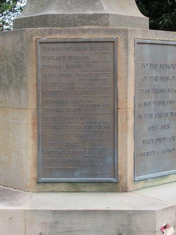
Thomas Hindson Biggins Pte Som. L.I. · Rowland Burdon Capt. & Flt. Comdr R.F.C. · Thomas Burns L/Cpl Durham L.I. · James Henry Francis . . . — — Map (db m125904) WM
Near Moor Terrace close to Bath Terrace, on the left when traveling east.
25pr Mk II Saluting Gun
Calibre 87.6mm (3.45 inch)
Range 12km (13,400 yards)
Rate of Fire 6-8 rounds per minute
Shell weight 11.3kg (25lb)
This 25 pounder is used today by The Heugh Gun Battery to fire blank charges as a . . . — — Map (db m125799) HM
Near Moor Terrace at Bath Terrace, on the left when traveling east.
25pr Mk II Saluting Gun. 1942
Calibre 87.6mm (3.45 inch)
Range 12km (13,400 yards)
Rate of Fire 6-8 rounds per minute
Shell weight 11.3kg (25lb)
The 25 pounder is considered to have been one of the finest field artillery pieces . . . — — Map (db m125797) HM
Near Moor Terrace at Bath Terrace, on the left when traveling east.
5.5 inch Gun Howitzer
Calibre 140mm (5.5 inch)
Range 14km (15,300 yards)
Rate of Fire 3 rounds per minute
Shell weight 36kg (80lb)
The 5.5 inch Howitzer came into service in 1942 in the Western Desert of North Africa against . . . — — Map (db m125800) HM
Near Moor Terrace at Bath Terrace, on the left when traveling east.
Original 6 inch Mk 24
Calibre 152mm (6 inch)
Range 23km (25,400 yards)
Rate of Fire 6 to 8 rounds per minute
Shell weight 50kg (112lb)
A 6 inch Mk 24 was mounted here and, with its powered turret, would have been about a . . . — — Map (db m125758) HM
Near Moor Terrace at Bath Terrace, on the left when traveling east.
Original 6 inch Mk VII
Calibre 152mm (6 inch)
Range 14km (15,700 yards)
Rate of Fire 5 to 7 rounds per minute
Shell weight 45kg (100lb)
The original gun emplaced here was a Vickers 6 inch Mk VII gun, the workhorse of 20th . . . — — Map (db m125746) HM
Near Moor Terrace at Bath Terrace, on the left when traveling east.
A Trophy From Sebastopol
This Cannon Was Captured From the Russian Army
At the Battle of Sebastopol
During the Crimean War (1854-56). In October, 1857
The then Secretary of State, Lord Panmure,
Offered the Cannon to Hartlepool Borough . . . — — Map (db m125833) HM
Near Moor Terrace at Bath Terrace, on the left when traveling east.
Bofors L/60 40mm Anti Aircraft Gun
Calibre 40mm (1.57 inch)
Anti Aircraft Ceiling 7.9km (26,000 feet)
Rate of Fire 120 rounds per minute
Shell weight 0.7kg (2lb) High Explosive
The Bofors was a British version of a Swedish . . . — — Map (db m125761) HM
Near Moor Terrace at Bath Terrace, on the left when traveling east.
At 7pm on 14th December 1914 Winston Churchill, First Lord of the Admiralty, was told that "a battle cruiser attack on the East Coast was probably imminent", although what the precise objectives were it was impossible to say.
The SMS Seydlitz, . . . — — Map (db m125831) HM
Near Moor Terrace at Bath Terrace, on the left when traveling east.
It was thought that a buoy which the German fleet used as a guide had been moved further inland and the nearness of the German ships to the coast was the salvation of the batteries. A longer range would have given a trajectory bringing a dropping . . . — — Map (db m125832) HM
Near Moor Terrace at Bath Terrace, on the left when traveling east.
Burney 3.7 inch Mk I Recoilless Rifle
Calibre 94mm (3.7 inch)
Range approx 1km (1090 yards)
Rate of Fire Unknown
Shell weight Unknown
The requirement for light, highly mobile anti tank weapons led to experiments with . . . — — Map (db m125767) HM
On W View Road at Thorpe Street, on the right when traveling west on W View Road.
The ancient tidal harbour of Hartlepool had become silted up by 1800 but was the obvious port from which to ship the coal of the South Durham collieries. From 1832 the dock was scoured by using sluices to release water from the Slake at low tide. . . . — — Map (db m125901) HM
Near Moor Terrace at Bath Terrace, on the left when traveling east.
This Tablet Marks the Place
Where the First Shell from the
Leading German Battle Cruiser
Struck at 8:10 A.M. on the
16th of December 1914
And Also Records the Place Where
(During the Bombardment)
The First Soldier Was Killed
On . . . — — Map (db m125803) HM WM
On W View Road at Thorpe Street, on the right when traveling east on W View Road.
Welcome to the
Headland
Ancient Borough
of Hartlepool
This Gateway Marker was erected
2001 AD to celebrate the 800th
Anniversary of the grant of a Charter by
King John to the citizens of Herterpool,
The historic Borough of . . . — — Map (db m125835) HM
Near Moor Terrace at Bath Terrace, on the left when traveling east.
L6 Wombat 120mm Recoilless Rifle
Calibre 120mm (4.7 inch)
Range 1.1km (1,200 yards)
Rate of Fire 4 rounds per minute
Shell weight 12.8 kg (28lb)
The WOMBAT (Weapon Of Magnesium, Battalion Anti Tank Gun) was Britain's light . . . — — Map (db m125801) HM
Near Moor Terrace at Bath Terrace, on the left when traveling east.
3.7 inch Static Mount Anti Aircraft Gun
The Malta Gun
Between 1940 and 1943 the island of Malta, "Britain's unsinkable aircraft carrier" suffered almost continuous siege in the most sustained bombing campaign of World War Two. Germany . . . — — Map (db m125760) HM
Near Moor Terrace at Bath Terrace, on the left when traveling east.
3.7 inch Mk I Anti Aircraft Gun
Calibre 93.9mm (3.7 inch)
Anti Aircraft Ceiling 9.7 km (31,000 feet)
Rate of Fire 10 rounds per minute
Shell weight 12.7kg (28lb)
The Vickers anti-aircraft gun was introduced to the British . . . — — Map (db m125765) HM
Near Moor Terrace at Bath Terrace, on the left when traveling east.
4.5 Inch Mk III Naval & Anti Aircraft Gun
4.5 Inch Mk III
Calibre 114mm (4.5 inch)
Range 18.2 km (19,990 yards)
Anti Aircraft Ceiling 9.1km (29,900 feet)
Rate of Fire 14 rounds per minute
Shell weight 25 kg (55lb)
The . . . — — Map (db m125757) HM
Near Moor Terrace at Bath Terrace, on the left when traveling east.
4.7 inch Naval / Coast Defence Gun
Calibre 120mm (4.7 inch)
Range 9km (9,900 yards)
Rate of Fire 5 to 6 rounds per minute
Shell weight 20.4 kg (45lb)
The 4.7 inch gun was the first 'modern' breech loader and was accepted into . . . — — Map (db m125766) HM
Near Moor Terrace at Bath Terrace, on the left when traveling east.
Naval Gun 4 inch QF Mk 4 on Mk XVI Mount 1945
Calibre 100mm (4 inch)
Range 16,300 yards
Rate of Fire 10 - 15 rounds per minute
Shell weight 31lb, 14kg
The Naval Gun 4 inch QF first appeared in 1895 with the Mark IV being . . . — — Map (db m125759) HM
Near Moor Terrace at Bath Terrace, on the left when traveling east.
Naval Gun Barrel 4.5 inch QF Mk III
Calibre 114mm (4.5 inch)
Range 18.2 km (19,990 yards)
Anti Aircraft Ceiling 9.1km (29,900 feet)
Rate of Fire 14 rounds per minute
Shell weight 25 kg (55lb)
In the 1930s a Naval gun was . . . — — Map (db m125745) HM WM
Near Marina Way at Maritime Avenue, on the left when traveling south.
The PS Wingfield Castle is a unique survivor of a type of passenger vessel which once was common across Britain. She is a symbol of the technical skill of local people, both during her construction on this very spot during the great depression of . . . — — Map (db m125686) HM
Near Marina Way at Maritime Avenue, on the left when traveling south.
PSS Wingfield Castle
PSS Wingfield Castle is the largest exhibit at the Museum of Hartlepool. She was built here in Hartlepool by William Gray & Co and launched in 1934. She served as a passenger ferry on the River Humber with her sister ships PSS . . . — — Map (db m125689) HM
Near Marina Way at Maritime Avenue, on the left when traveling south.
There would be approximately 12 miles of rope on board an average frigate of the Napoleonic era.
The Standing Rigging supports the masts. It is very thick as it has to bear a great deal of weight. These ropes could be as large as 10cm . . . — — Map (db m125685) HM
Near Marina Way at The Highlight, on the left when traveling south.
In Memory Of All Those
Who Lost Their Lives At Sea
( eleven granite tablets, set into the pavement, list the names of lost sailors ) — — Map (db m125687) HM
Near Marina Way at Maritime Avenue, on the left when traveling south.
The Shipwrecked
Fishermen & Mariners
Royal Benevolent Society
16 Wilfred Street London S.W.I.
Founded 1833 For The Alleviation Of
Every Phase Of Shipwreck Distress
Among The Seafaring Population
And Their Dependents
Over 1,000,000 . . . — — Map (db m125690) HM
Near Moor Terrace at Bath Terrace, on the left when traveling east.
The Bombardment
of the Hartlepools
This memorial commemorates all those
across the Hartlepools who were killed or wounded
due to the naval bombardment of the 16th December 1914.
At least 114 civilians, 9 soldiers and 7 sailors were . . . — — Map (db m125834) HM WM
On W View Road at Thorpe Street, on the right when traveling west on W View Road.
Throston Engine House was built 1838-1840 to accommodate a steam winding engine which hauled the coal wagons of the Stockton and Hartlepool Railway up 14 feet (4.3 metres) to the staiths of the Hartlepool Railway, at 3d (old pence) per ton of . . . — — Map (db m125902) HM