6 entries match your criteria.
Related Historical Markers
Historic St. Andrews Beach
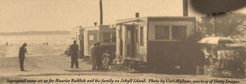
Marker detail: Segregated camp set up for Maurice Ruddick and his family on Jekyll Island
SHOWN IN SOURCE-SPECIFIED ORDER
| On South Beachview Drive, 2.3 miles south of Jekyll Island Causeway (Route 520), on the right when traveling south. |
| | On October 23, 1958, a coal mining disaster in Springhill, Nova Scotia trapped 174 men underground. The coverage of this disaster was the first international event to be broadcast live on television.
In the hope of harnessing the media . . . — — Map (db m115128) HM |
| On South Beachview Drive, 2.3 miles south of Jekyll Island Causeway (Georgia Route 520), on the right when traveling south. |
| |
On March 6, 1948, Jekyll Island opened as a state park for the citizens of Georgia. However, the new public seashore was not available to everyone, at first. Because of segregation, African Americans could not visit many areas of Jekyll Island, . . . — — Map (db m115135) HM |
| Near South Beachview Drive, 2.3 miles Jekyll Island Causeway (Georgia Route 520), on the left when traveling south. |
| |
The Beach Pavilion in front of you opened on September 25, 1955 to great fanfare, as St. Andrews Beach became the first public beach in Georgia to welcome African Americans. Celebrations included a motorcade, dedication ceremony, and music by the . . . — — Map (db m115137) HM |
| Near South Beachview Drive, 2.3 miles south of Jekyll Island Causeway (Georgia Route 520), on the left when traveling south. |
| |
The St. Andrews Beach Corporation formed in early 1956 to build a motel and restaurant here on Jekyll Island's once segregated South End. The company included many successful black business owners from Brunswick. In partnership with the Jekyll . . . — — Map (db m115139) HM |
| Near South Beachview Drive, 2.3 miles south of Jekyll Island Causeway (Georgia Route 520), on the left when traveling south. |
| |
From the late-1800s until the mid-1960s, Jim Crow laws enforced racial segregation in the South. These laws prevented African Americans from enjoying equal access to the same public spaces as white people, including restaurants, buses, schools, . . . — — Map (db m115140) HM |
| Near South Beachview Drive, 2.3 miles south of Jekyll Island Causeway (Georgia Route 520), on the left when traveling south. |
| |
From 1959 to 1966, the Dolphin Club Lounge provided lively entertainment for visitors to the historically black St. Andrews Beach.
Juke joints like this one once stretched across the southeastern United States. On remote Jekyll Island, the . . . — — Map (db m115141) HM |
May. 19, 2024