5 entries match your criteria.
Related Historical Markers
By James Thomson, October 11, 2010
The Yellow Fever of 1855 Marker
SHOWN IN SOURCE-SPECIFIED ORDER
| On North Street at Dinwiddie Street, on the right when traveling east on North Street. |
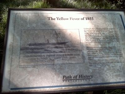
| | On June 19th, 1855, following a twelve day quarantine, the merchant ship Benjamin Franklin arrived from the West Indies and docked at Gosport Shipyard for repairs. While emptying its bilge, mosquitoes carrying yellow fever were released. After . . . — — Map (db m36892) HM |
| On Fort Lane at Blair Street, on the right when traveling north on Fort Lane. |
| | Cedar Grove Cemetery was established in 1831 as the first secular cemetery by the Town of Portsmouth. It was placed on the National Register of Historic Places in 1992. The four-acre parcel cost $400.00 and was sectioned into 167 lots which sold for . . . — — Map (db m119425) WM |
| Near Effingham Street at Crawford Parkway, on the right when traveling north. |
| | In June 1855, the steamer Franklin put into Norfolk for repairs while sailing from the West Indies to New York. Mosquitoes carrying yellow fever escaped when the vessel docked. The Naval Hospital’s first yellow fever patients came from . . . — — Map (db m83935) HM |
| On Rixey Place north of John Paul Jones Court, on the right when traveling north. |
| | This was begun in 1827 and opened in 1830. The hospital was taxed to its capacity in the Great Yellow Fever Epidemic in 1855 which decimated Portsmouth and Norfolk. This hospital has cared for the sick and wounded of the Navy in all wars of the . . . — — Map (db m216386) HM |
| On London Boulevard (Virginia Route 141) at Ruth Brown Way, on the right when traveling east on London Boulevard. |
| | I.C. Norcom (1856-1916) was an African American educator and administrator who served Portsmouth schools for more than 30 years. The first school to bear his name opened in 1920 three quarters of a mile southeast of here. Principal William E. . . . — — Map (db m113668) HM |
May. 3, 2024