4 entries match your criteria.
Related Historical Markers
By Leah Tibbs, October 26, 2018
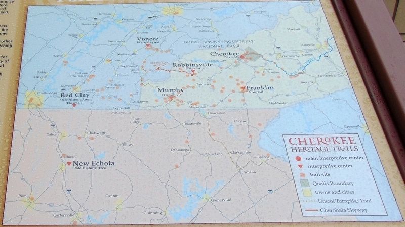
Cherokee Heritage Trails Map
SHOWN IN SOURCE-SPECIFIED ORDER
| Near Peachtree Street at Alpine Street, on the right when traveling north. |
| | Cherokee Heritage Trails (Tsalagi Usdi Nvnohi) wind through the mountains of North Carolina, Tennessee, and Georgia, in the heart of Cherokee homelands that once encompassed more than 140,000 square miles. Here, where Cherokee people have lived . . . — — Map (db m134947) HM |
| On Cherohala Skyway (Bypass Route 165) at Herford Street, on the left when traveling west on Cherohala Skyway. |
| | Cherokee Heritage Trails (Tsalagi Usdi Nvnohi) wind through the mountains of North Carolina, Tennessee, and Georgia, in the heart of Cherokee homelands that once encompassed more than 140,000 square miles. Here, where Cherokee people have lived . . . — — Map (db m75410) HM |
| | Cherokee Heritage Trails (Tsalagi Usdi Nvnohi) wind through the mountains of North Carolina, Tennessee, and Georgia, in the heart of Cherokee homelands that once encompassed more than 140,000 square miles. Here, where Cherokee people have lived for . . . — — Map (db m75440) HM |
| On East Main Street (Business U.S. 441) at Nikwasi Lane, on the left when traveling east on East Main Street. |
| | You are standing on land that has been part of a town for about three thousand years. This mound was the spiritual, political, and physical center of the Cherokee town of Nikwasi. A council house or town house on top of the mound held the sacred . . . — — Map (db m75523) HM |
May. 7, 2024