3 entries match your criteria.
Related Historical Markers
Three markers designating the Cherokee boundary between 1767 and 1777.
By Brian Scott, February 7, 2011
Cherokee Boundary (1767) Marker -
Front
SHOWN IN SOURCE-SPECIFIED ORDER
| |
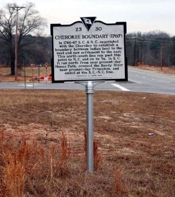
[Front]:
In 1766-67 S.C. & N.C. negotiated with the Cherokee to establish a boundary between Indian land to the west and new settlement to the east. This north-south line ran past this point to N.C. and on to Va. In S.C. it ran north . . . — — Map (db m49086) HM |
| |
[Front]:
In 1766-67 S.C. & N.C. negotiated with the Cherokee to establish a boundary between Indian land to the west and new settlement to the east. This north-south line ran past this point to N.C. and on to Va. In S.C. it ran north . . . — — Map (db m8446) HM |
| | [Front Side]:
The Cherokee sided with the British during the American Revolution, and in 1776 Maj. Andrew Williamson's S.C. militia destroyed their "Lower Towns" in what is now S.C. He then cooperated with the N.C. militia in expeditions . . . — — Map (db m14351) HM |
May. 19, 2024