Near Richmond in Henrico County, Virginia — The American South (Mid-Atlantic)
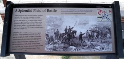
A Splendid Field of Battle
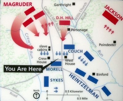
Throughout July 1, Lee gathered his army out of sight in the distant woods, its numbers reduced to 70,000. By late afternoon only the sounds of scattered artillery fire filled the air. Then poor communication combined with misunderstanding of orders led to repeated Confederate attacks. Southern troops found themselves funneled together and forced to charge straight into the Federal batteries. The ground to your front bore witness to carnage on a grand scale. Over 30,000 Confederates took part in the advances. By day’s end the battle claimed 8,000 casualties; over half wore gray.
“There was a splendid field of battle on the high plateau where the greater part of the troops, artillery, etc. were placed. It was a magnificent sight….”
Andrew A. Humphreys, chief topographical engineer for the Union Army
Erected 2010 by Richmond National Battlefield Park.
Topics. This historical marker is listed in this topic list: War, US Civil. A significant historical date for this entry is July 1, 1864.
Location. 37° 24.779′ N, 77° 15.016′ W. Marker is near Richmond, Virginia, in Henrico County. Marker can be reached from Willis Church Road (Virginia Route 156) 0.3 miles south of Carters Milll Road, on the right when traveling south. Touch for map. Marker is at or near this postal address: 9100 Willis Church Rd, Henrico VA 23231, United States of America. Touch for directions.
Other nearby markers. At least 8 other markers are within walking distance of this marker. Malvern Hill (a few steps from this marker); a different marker also named Malvern Hill (within shouting distance of this marker); Southern Valor vs. Union Firepower (within shouting distance of this marker); Union Firepower (within shouting distance of this marker); Battlefield of Malvern Hill (about 400 feet away, measured in a direct line); Battlefield Landscape (about 400 feet away); Seven Days Battles (about 400 feet away); The West House (about 400 feet away). Touch for a list and map of all markers in Richmond.
Related marker. Click here for another marker that is related to this marker. Old Marker At This Location titled "The Last Day".
Also see . . .
1. Richmond National Battlefield Park. National Park Service (Submitted on August 22, 2010.)
2. Malvern Hill. Civil War Preservation Trust (Submitted on August 22, 2010, by Bernard Fisher of Richmond, Virginia.)
3. Malvern Hill Battlefield Podcast. CivilWarTraveler.com (Submitted on August 22, 2010, by Bernard Fisher of Richmond, Virginia.)
Credits. This page was last revised on November 5, 2021. It was originally submitted on August 22, 2010, by Bernard Fisher of Richmond, Virginia. This page has been viewed 1,025 times since then and 16 times this year. Photos: 1, 2, 3, 4. submitted on August 22, 2010, by Bernard Fisher of Richmond, Virginia.


