6 entries match your criteria.
Related Historical Markers
To better understand the relationship, study each marker in the order shown.
By Richard E. Miller, October 20, 2007
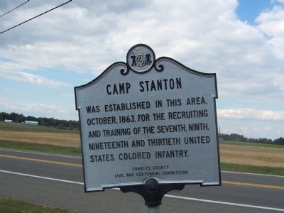
Camp Stanton Marker
SHOWN IN SOURCE-SPECIFIED ORDER
| On Prince Frederick Road (Maryland Route 231) at Mill Creek Road/Bendict Avenue cut off, on the right when traveling east on Prince Frederick Road. |
| | Camp Stanton was established in this area, October, 1863, for the recruiting and training of the Seventh, Ninth, Nineteenth and Thirtieth United States Colored Infantry. — — Map (db m4112) HM |
| On Deep Bottom Road, on the left. Reported permanently removed. |
| |
After the Battle of Cold Harbor in June 1864, Grant and Lee shifted their armies to Petersburg; but Grant did not wish to abandon the Richmond front entirely. He had Gen. Benjamin Butler position a small force from his Army of the James here at . . . — — Map (db m193868) HM |
| On New Market Road (Scenic State Highway 5) at Bypass Interstate 295, on the left when traveling east on New Market Road. |
| | On 28 September 1864, elements of Maj. Gen. Benjamin F. Butler’s Army of the James crossed the James River to assault the Confederate defenses of Richmond. At dawn on 29 September, 6 regiments of U.S. Colored Troops fought with exceptional valor . . . — — Map (db m181439) HM |
| On Battlefield Park Road, on the left when traveling south. Reported permanently removed. |
| | Confederate Fort Gilmer loomed as a major obstacle to any advance on Richmond. On the afternoon of September 29, 1864, several regiments of black troops stormed these works only to be driven back. A portion of the 7th United States Colored Troops, . . . — — Map (db m24823) HM |
| On Main Street (State Highway 5) at Nicholson Street, on the left when traveling north on Main Street. |
| | Here Maj. Gen. Godfrey Weitzel, commander of the Army of the James, entered and took possession of Richmond at 8:15 A.M. on 3 April 1865 after receiving the surrender of the confederate capital a few miles east. The first units of Weitzel's command . . . — — Map (db m15698) HM |
| On Branch Street at Flower Street, on the right when traveling east on Branch Street. Reported permanently removed. |
| | Isaiah "Uncle Zear" Fassett was born into slavery southeast of here in Sinepuxent in 1844. His owner, Sarah A. Bruff, released him from bondage at age nineteen on November 11, 1863, when the U.S. Army paid her $300 in compensation. That same day, . . . — — Map (db m15695) HM |
May. 7, 2024