Marker Logo HMdb.org THE HISTORICAL
MARKER DATABASE
“Bite-Size Bits of Local, National, and Global History”


5 entries match your criteria.  


Related Historical Markers

To better understand the relationship, study each marker in the order shown.
 
Marker at Fort Gilmer image, Touch for more information
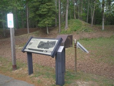
By Bill Coughlin, April 24, 2007
Marker at Fort Gilmer
SHOWN IN SOURCE-SPECIFIED ORDER
1 Virginia, Henrico County, Richmond — Black Troops Attack at Chaffin’s FarmFort Gilmer – 1864
On Battlefield Park Road, on the left when traveling south. Reported permanently removed.
2 Maryland, Charles County, Benedict — Camp Stanton
On Prince Frederick Road (Maryland Route 231) at Mill Creek Road/Bendict Avenue cut off, on the right when traveling east on Prince Frederick Road.
3 Virginia, Henrico County, Richmond — Deep Bottom LandingA Vital Link
On Deep Bottom Road, on the left. Reported permanently removed.
4 Virginia, Henrico County, Richmond — V-26 — Battle of New Market Heights
On New Market Road (Scenic State Highway 5) at Bypass Interstate 295, on the left when traveling east on New Market Road.
5 Virginia, Richmond, Shockoe Bottom — SA-41 — Union Army Enters Richmond
On Main Street (State Highway 5) at Nicholson Street, on the left when traveling north on Main Street.


CeraNet Cloud Computing sponsors the Historical Marker Database.
This website earns income from purchases you make after using our links to Amazon.com. We appreciate your support.
Paid Advertisement
May. 4, 2024