5 entries match your criteria.
Related Historical Markers
To better understand the relationship, study each marker in the order shown.
By Devry Becker Jones (CC0), May 8, 2021
The Battle of McDowell Marker
SHOWN IN SOURCE-SPECIFIED ORDER
| On Highland Turnpike (U.S. 250), on the left when traveling west. Reported permanently removed. |
| |
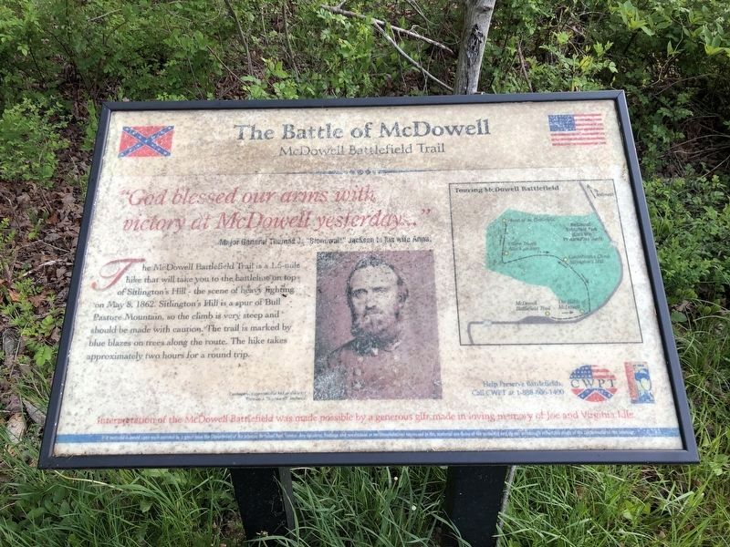
"God blessed our arms with victory at McDowell yesterday…"
Major General's Thomas J. "Stonewall" Jackson to his Wife Anna.
The McDowell Battlefield Trail is a 1.5-mile hike that will take you to the . . . — — Map (db m62903) HM |
| Near U.S. 250, on the right when traveling east. Reported permanently removed. |
| | In the spring of 1862 Confederate fortunes seemed to have gone from bad to worse. Union forces had won several key battles in the West, while the U.S. Navy was establishing its coastal blockade and Major General George B. McClellan’s Army of the . . . — — Map (db m165817) HM |
| Near U.S. 250, on the right when traveling east. Reported permanently removed. |
| | “… [The 31st Virginia] came close to the 3rd and saluted them, and called them by name, and proceeded with the slaughter.” Andrew Price, 3rd Virginia Most of Stonewall Jackson’s Confederates climbed Sitlington’s Hill through a ravine off to . . . — — Map (db m194639) HM |
| Near U.S. 250, on the right when traveling east. Reported permanently removed. |
| | Major General Edward Johnson commanded the Confederates on the crest overlooking the town of McDowell. Johnson spread his line along the hilltop, anchoring his right flank on the knoll to your right. Stonewall Jackson remained in the valley below, . . . — — Map (db m16685) HM |
| Near U.S. 250, on the right when traveling east. Reported permanently removed. |
| | The Confederate 12th Georgia Infantry Regiment held this exposed crest overlooking McDowell. Milroy’s Union troops assaulted this hilltop from two directions – on the left and the right. The Confederates held their ground against repeated attacks . . . — — Map (db m16689) HM |
May. 4, 2024