2 entries match your criteria.
Related Historical Markers
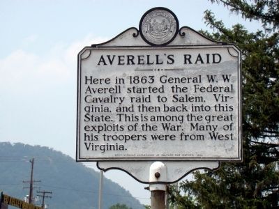
These two markers are identical but are in distinct parts of the City of Keyser.
By J. J. Prats, July 5, 2010
Averell’s Raid Face of Marker
SHOWN IN SOURCE-SPECIFIED ORDER
| On East Piedmont Street at North Davis Street, on the right when traveling north on East Piedmont Street. |
| | Keyser. Between 1861–1865, Keyser, then New Creek, was sought by the North and South. It changed hands fourteen times. Fort Fuller, where Potomac State Collect stands, was supported by a series of forts girding the town.
Averell’s . . . — — Map (db m32836) HM |
| On South Mineral Street (U.S. 220) just south of Carskadon Lane, on the right when traveling north. |
| |
Keyser. Between 1861–1865, Keyser, then New Creek, was sought by the North and South. It changed hands fourteen times. Fort Fuller, where Potomac State Collect stands, was supported by a series of forts girding the town.
Averell’s . . . — — Map (db m32832) HM |
May. 5, 2024