5 entries match your criteria.
Related Historical Markers
To better understand the relationship, study each marker in the order shown.
By David Seibert, June 20, 2009
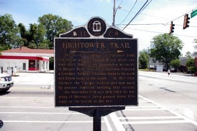
Hightower Trail Marker
SHOWN IN SOURCE-SPECIFIED ORDER
| On South Cherokee Road (Georgia Route 11) at Hightower Trail, on the right when traveling south on South Cherokee Road. |
| On Stone Mountain Freeway (U.S. 78) 0.2 miles west of West Park Place Boulevard, on the right when traveling west. |
| On Hightower Trail, 0.1 miles west of Huntcliff Trace, on the right when traveling west. |
| On Azalea Drive at Club Drive, on the right when traveling west on Azalea Drive. |
| On Shallowford Road NE at Mountain Trace NE, on the right when traveling east on Shallowford Road NE. |
May. 16, 2024