4 entries match your criteria.
Related Historical Markers
To better understand the relationship, study each marker in the order shown.
By Dave Zollinger, April 26, 2010
Indiana Territory Line Marker
SHOWN IN SOURCE-SPECIFIED ORDER
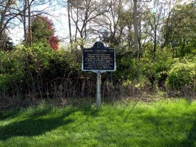
| On U.S. 33, 0.3 miles north of County Road 17, on the right when traveling south. |
| | The boundary between Indiana and Michigan territories was established in 1805. Just before Indiana became a state in 1816, the line was moved ten miles north to give Indiana frontage on Lake Michigan. — — Map (db m44849) HM |
| On U.S. 31 at Johnson Road, on the right when traveling north on U.S. 31. |
| | The boundaries between Indiana and Michigan territories was established on June 30, 1805. Just before Indiana became a state in 1816, the line was moved ten miles north to provide frontage on Lake Michigan. — — Map (db m240358) HM |
| On Pine Lake Avenue north of Weller / Truesdell Ave., on the right when traveling north. |
| | Side One
Northwest Territory formed 1787; Indiana Territory formed 1800. Admission of Ohio 1803 and formation of Michigan Territory 1805 established Indiana Territory's northern boundary at southern tip of Lake Michigan. When Indiana became . . . — — Map (db m43369) HM |
| On State Road 120 at Fountain Road, on the left when traveling east on State Road 120. |
| |
(Front Side)
Indiana admitted by the U.S. Congress as nineteenth state 1816. Enabling Act moved northern boundary ten miles north of southernmost tip of Lake Michigan providing direct access to the lake. Boundary first surveyed 1817 by . . . — — Map (db m61519) HM |
May. 2, 2024