3 entries match your criteria.
Related Historical Markers
To better understand the relationship, study each marker in the order shown.
By Richard E. Miller, June 27, 2010
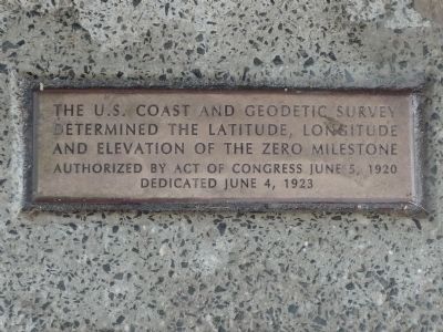
Plaque in the sidewalk
SHOWN IN SOURCE-SPECIFIED ORDER
| |
The U.S. Coast and Geodetic Survey determined the latitude, longitude and elevation of the Zero Milestone. Authorized by Act of Congress, June 5, 1920. Dedicated June 4, 1923.
Point for the measurement of distances from Washington on . . . — — Map (db m32486) HM |
| | The stone marking the Washington Meridian was formerly located 52 feet, nine inches west of this tablet which was presented by the Army and Navy Chapter, Daughters of the American Revolution. — — Map (db m82518) HM |
| | Position of Jefferson
Pier, erected Dec. 18, 1804
Recovered and re-erected
Dec. 2, 1889
. . .
District of Columbia — — Map (db m112544) HM |
May. 7, 2024