Near Richmond in Henrico County, Virginia — The American South (Mid-Atlantic)
Richmond Battlefield
Malvern Hill
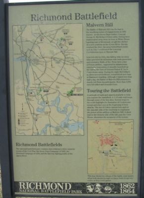
Less wooded in 1862, this hilltop with its steep sides provided its defenders with both protection and extensive fields of fire. From here a line of Union artillery, supported by infantrymen, repulsed a long series of assaults launched up the hill by the men of General Robert E. Lee's Confederate army. During the night McClellan's soldiers moved southeast, toward their new base at Harrison's Landing. Although it lasted less than half a day, the Battle of Malvern Hill extracted a deadly toll from its participants. More than 8,000 men fell killed and wounded here.
Touring the Battlefield
A network of trails and signs is available to help you explore the battlefield. A 1 1/2-mile trail loops through some of the key sites. Several stops to the north highlight the formation of Confederate troops and place you at the beginning of their attacks. The line of Union cannon here and on the opposite side of the road help to emphasize the power of the artillery at Malvern Hill. A short trail to the western side of the hill, past the Crew House, illustrates the steepness of the terrain.
Richmond Battlefields
The national battlefield park contains sites relating to three separate events of the Civil War: the Seven Days Campaign of 1862, the Overland Campaign of 1864, and the late-war fighting north of the James River.
Erected by Richmond National Battlefield Park - National Park Service - Department of the Interior.
Topics. This historical marker is listed in this topic list: War, US Civil. A significant historical month for this entry is July 1926.
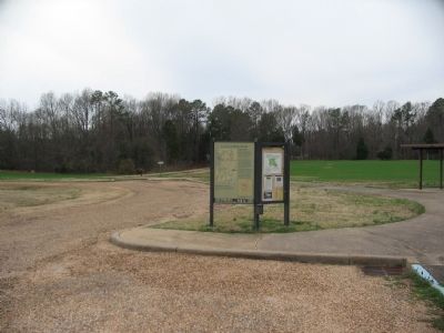
Location. This marker has been replaced by another marker nearby. It was located near 37° 24.773′ N, 77° 15.006′ W. Marker was near Richmond, Virginia, in Henrico County. Marker was on Willis Church Road (State Highway 156), on the right when traveling south. Located at the parking area for the Malvern Hill unit of the Richmond National Battlefield Park. Touch for map. Marker was at or near this postal address: 9100 Willis Church Rd, Henrico VA 23231, United States of America. Touch for directions.
Other nearby markers. At least 8 other markers are within walking distance of this location. Malvern Hill (here, next to this marker); A Splendid Field of Battle (a few steps from this marker); a different marker also named Malvern Hill

2. Malvern Hill - CWPT
Civil War Preservation Trust's efforts to preserve portions of the battlefield.
Click for more information.
Click for more information.
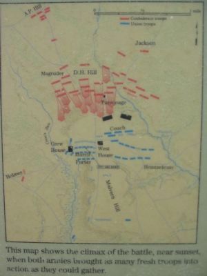
More about this marker. A large map on the left shows the Richmond National Battlefield Park system. On the left a map provides an overview of the battle: This map shows the climax of the battle, near sunset, when both armies brought as many fresh troops into action as they could gather.
Related marker. Click here for another marker that is related to this marker. New Marker At This Location titled "Malvern Hill".

Photographed By Craig Swain, March 21, 2010
5. Map on the Billboard
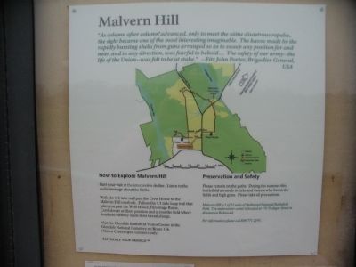
On the billboard side of the kiosk is this map of the park. The map has a quote:
"As column after column advanced, only to meet the same disastrous repulse, the sight became one of the most interesting imaginable. The havoc made by the rapidly bursting shells from guns arranged so as to sweep any position far and near, and in any direction, was fearful to behold.... The safety of our army - the life of the Union - was felt to be at stake." - Fitz John Porter, Brigadier General, USA.
"As column after column advanced, only to meet the same disastrous repulse, the sight became one of the most interesting imaginable. The havoc made by the rapidly bursting shells from guns arranged so as to sweep any position far and near, and in any direction, was fearful to behold.... The safety of our army - the life of the Union - was felt to be at stake." - Fitz John Porter, Brigadier General, USA.
Credits. This page was last revised on November 5, 2021. It was originally submitted on March 28, 2010, by Craig Swain of Leesburg, Virginia. This page has been viewed 1,137 times since then and 18 times this year. Photos: 1, 2, 3, 4, 5. submitted on March 28, 2010, by Craig Swain of Leesburg, Virginia.


