5 entries match your criteria.
Related Historical Markers
To better understand the relationship, study each marker in the order shown.
By David Anderson, February 28, 2008
British Retreat Route Marker
SHOWN IN SOURCE-SPECIFIED ORDER
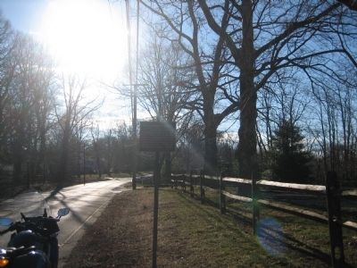
| On King's Highway East, on the right when traveling west. |
| | Seeking the Protection of Middletown's hills on the 29th of June 1778, the day after the Battle of Monmouth, the Main British Army under Gen. Sir Henry Clinton withdrew along this road toward Sandy Hook, whence they embarked for New York a week . . . — — Map (db m116869) HM |
| On King’s Highway East at Chapel Hill Road on King’s Highway East. |
| | For a week following the Battle of Monmouth, the main British army under Gen. Sir Henry Clinton spread its encampment both side of this road while awaiting transport from Sandy Hook. They embarked for New York July 5, 1778. — — Map (db m5842) HM |
| On Monmouth Avenue at Sears Avenue on Monmouth Avenue. |
| | Middletown Township Historic District. Summer camping ground of the Indians on their Minisink Trail, which became part of the King’s Highway. Location of the Burge’s Mill in Colonial Times; British campsite after the Battle of Monmouth. A . . . — — Map (db m116864) HM |
| On Monmouth Avenue at Navesink Avenue on Monmouth Avenue. |
| | For a week following the Battle of Monmouth, the main British Army under Gen. Sir Henry Clinton spread its encampment both sides of this road while awaiting transport from Sandy Hook. They embarked for New York July 5, 1778. — — Map (db m5806) HM |
| On Navesink Avenue (County Route 8B) near Woodhaven Lane, on the right when traveling north. |
| | For a week following the Battle of Monmouth, the main British Army under Gen. Sir Henry Clinton spread its encampment both sides of this road while awaiting transport from Sandy Hook. They embarked for New York July 5, 1778. — — Map (db m5804) HM |
Apr. 30, 2024