6 entries match your criteria.
Related Historical Markers
Take a tour of the Baltimore Riot Trail.
By William Pfingsten, September 9, 2007
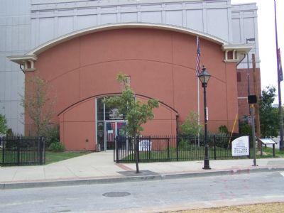
President Street Station
SHOWN IN SOURCE-SPECIFIED ORDER
| On President Street at Fleet Street, on the right when traveling south on President Street. Reported permanently removed. |
| |
In 1861, as the Civil War began, Baltimore secessionists hoped to stop rail transportation to Washington and isolate the national capital. On April 19, the 6th Massachusetts Regiment arrived here at the Philadelphia, Wilmington and Baltimore . . . — — Map (db m2418) HM |
| On President Street at Fawn Street, on the left when traveling north on President Street. Reported permanently removed. |
| |
On April 19, 1861, Confederate sympathizers attacked the 6th Massachusetts Infantry Regiment as it changed trains en route to Washington, which the secessionists hoped to isolate. To learn more about the Baltimore Riot, the city’s role in . . . — — Map (db m6208) HM |
| On President Street at Pratt Street, on the left when traveling north on President Street. |
| | (Preface): On April 19, 1861, Confederate sympathizers attacked the 6th Massachusetts Infantry Regiment as it changed trains en route to Washington, which the secessionists hoped to isolate. To learn more about the Baltimore Riot, the . . . — — Map (db m6209) HM |
| On East Pratt Street at Commerce Street, on the right when traveling east on East Pratt Street. Reported permanently removed. |
| |
On April 19, 1861, Confederate sympathizers attacked the 6th Massachusetts Infantry Regiment as it changed trains en route to Washington, which the secessionists hoped to isolate. To learn more about the Baltimore Riot, the city’s role in . . . — — Map (db m71978) HM |
| On Light Street (Maryland Route 2) at East Pratt Street, on the left when traveling south on Light Street. Reported permanently removed. |
| | On April 19, 1861, Confederate sympathizers attacked the 6th Massachusetts Infantry Regiment as it changed trains en route to Washington, which the secessionists hoped to isolate. To learn more about the Baltimore Riot, the city's role in . . . — — Map (db m6151) HM |
| Near South Howard Street near West Camden Street. Reported damaged. |
| |
On April 19, 1861, Confederate sympathizers attacked the 6th Massachusetts Infantry Regiment as it changed trains en route to Washington, which the secessionists hoped to isolate. To learn more about the Baltimore Riot, the city’s role . . . — — Map (db m37538) HM |
May. 5, 2024