3 entries match your criteria.
Related Historical Markers
Fort Henry by markers.
By Currey Russell, March 6, 2011
Fort Henry Marker
SHOWN IN SOURCE-SPECIFIED ORDER
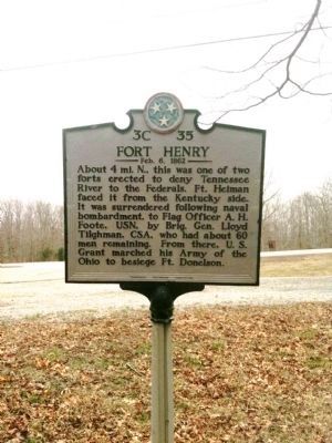
| | About 4 mi. N., this was one of two forts erected to deny Tennessee River to the Federals. Ft. Heiman faced it from the Kentucky side. It was surrendered following naval bombardment, to Flag Officer A.H. Foote, USN, by Brig. Gen. Lloyd Tilghman, . . . — — Map (db m82953) HM |
| | This site of the first Union attack on river routes in the West lies below Kentucky Lake. Only the easternmost rifle pits remain above water. Because of the high water in the fort, only Capt. Taylor's Co. B. First Regt. Tenn. Art., stayed to slow . . . — — Map (db m21282) HM |
| | Here was formerly a road following a telegraph line between Dover and Tennessee River. Following Ft. Henry’s capture, Grant’s Army of the Ohio marched on Ft. Donelson in two columns, the northernmost on this road. Leading in battle formation was the . . . — — Map (db m21295) HM |
Apr. 30, 2024