Marker Logo HMdb.org THE HISTORICAL
MARKER DATABASE
“Bite-Size Bits of Local, National, and Global History”


7 entries match your criteria.  


Related Historical Markers

Other Burr Truss Bridges on HMDB.org
 
Eugene Covered Bridge and Marker image, Touch for more information
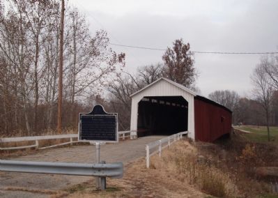
By Al Wolf, November 18, 2007
Eugene Covered Bridge and Marker
SHOWN IN SOURCE-SPECIFIED ORDER
1 Indiana, Vermillion County, Eugene — 83.1995.2 — Eugene Covered Bridge
Near North Main Street.
2 Indiana, Vermillion County, Newport — 83.1995.1 — Newport Covered Bridge
On County Road 50 (AKA: Hopkins Street), 0.6 miles State Road 63, on the right when traveling west.
3 New Hampshire, Grafton County, Haverhill — 136 — The Bedell Bridge
On Meadow Lane, 0.8 miles west of Dartmouth College Highway (New Hampshire Route 10), on the right when traveling west.
4 Virginia, Shenandoah County, New Market — AB-1 — Meem’s Bottom Covered Bridge
On Old Valley Turnpike (U.S. 11) south of Wissler Road, on the right when traveling south.
5 West Virginia, Marion County, Barrackville — Barrackville Covered Bridge
On Pike Street / Monumental Road (County Route 21) at Buffalo Road (Local Route 250/32), on the right when traveling north on Pike Street / Monumental Road.
6 West Virginia, Randolph County, Beverly — Lemuel Chenoweth House
On Water Street at Bridge Street (West Virginia Road 37-8), on the right when traveling south on Water Street.
7 Vermont, Bennington County, Old Bennington, North Bennington — Henry Covered Bridgeacross the Walloomsac River
On Murphy Road near Ore Bed Road, on the left when traveling north.
 
 
CeraNet Cloud Computing sponsors the Historical Marker Database.
This website earns income from purchases you make after using our links to Amazon.com. We appreciate your support.
Paid Advertisement
May. 19, 2024