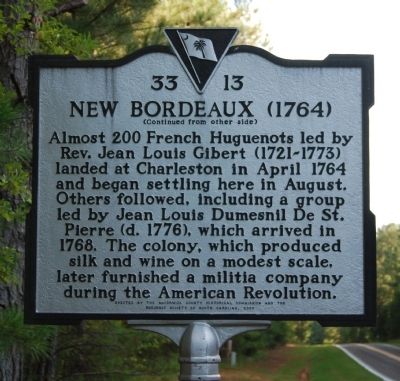
The town of New Bordeaux, the last of seven French Huguenot colonies founded in colonial S.C. and the only one in the upcountry, was established 1 mi. E in 1764. After Protestants fleeing religious persecution in France petitioned the British . . . — — Map (db m51286) HM
Badwell
Three miles west is the site of "Badwell," home of James Louis Petigru (1789-1863), leader of opposition to secession in South Carolina, outstanding Charleston lawyer, and S.C. Attorney General. He studied at Willington Academy under . . . — — Map (db m11456) HM
About four miles southeast is the site of the American Revolutionary Battle of Long Cane. On December 12, 1780, Lieutenant Colonel Isaac Allen and a British force of 400-500 men defeated Colonel Elijah Clarke and 100 Americans, an advanced . . . — — Map (db m241074) HM
Dorn's Mill. Built ca. 1899, this steam-powered mill employed a milling process pioneered earlier by inventor Oliver Evans, which virtually eliminated manual labor. First known as the McCormick Enterprise Ginnery, the mill became the . . . — — Map (db m243241) HM
Built ca. 1854 on a mill site in use since the 1770s, this large brick building on Little River was used for grinding corn, wheat, and other grains. A post office and various commercial enterprises operated near the mill during the 1800s. The . . . — — Map (db m18890) HM
Driven from the area at the start of the Cherokee War, settlers from Long Canes returned in the fall of 1760 and, under the protection of a party of Chickasaw Indians, reclaimed the land by building Fort Boone near here. — — Map (db m25200) HM
Three miles west is the site of an attack by Cherokee Indians upon settlers of Long Canes in the Cherokee War of 1759-1761. There on February 1, 1760, about 150 settlers, refugeeing to Augusta, were overtaken by 100 Cherokee warriors. . . . — — Map (db m11640) HM
Cherry Hill
Three miles southwest is "Cherry Hill," site of the home of George McDuffie (1790-1851), orator of nullification, member of the U.S. House of Representatives and the U.S. Senate, Major General of the State Militia, and Governor of . . . — — Map (db m11461) HM