By Jeff Leichsenring, August 16, 2023
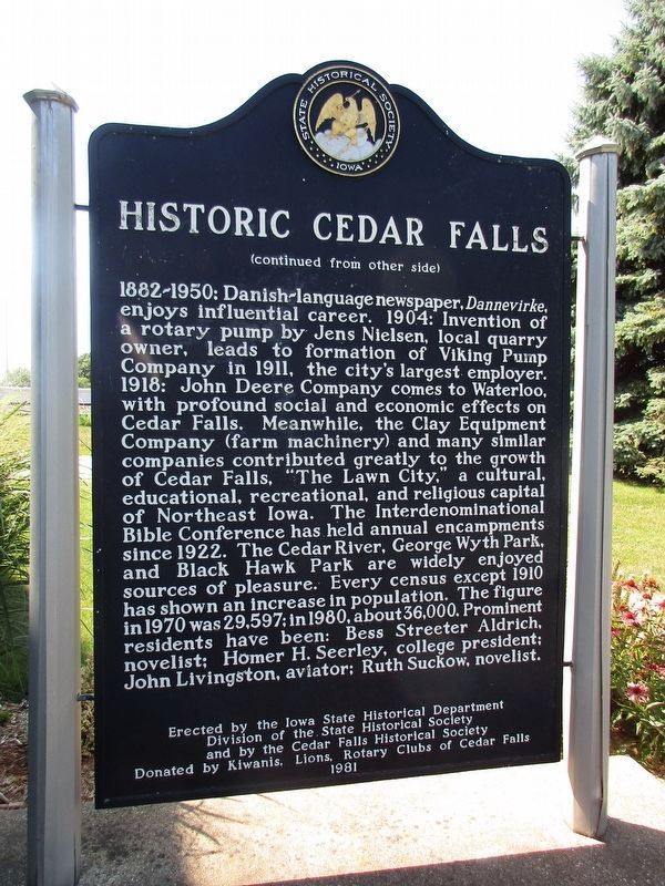
Historic Cedar Falls Marker Reverse
| Near U.S. 63, 0.7 miles north of East Eldora. |
| Near Interstate 80 at milepost 270,, 1 miles west of Rose Avenue (County Highway X64), on the right when traveling west. |
| Near Interstate 80 at milepost 270,, 1 miles west of Rose Avenue (County Highway X64), on the right when traveling west. |
| Near Interstate 35 south of Iowa Highway 34, on the right when traveling south. |
| Near Interstate 80 at milepost 119,, 1.9 miles east of Ute Avenue (County Road R22), on the right when traveling east. Reported permanently removed. |
| Near Interstate 35 north of County Highway J52, on the right when traveling north. |
| Near Monument Drive, 0.2 miles east of Mines of Spain Road. |
| On West Broad Street at North Main Street, on the right when traveling west on West Broad Street. |
| Near Interstate 80 at milepost 208,, 2.6 miles east of B Avenue (County Road V38), on the right when traveling east. |
| Near Interstate 80 at milepost 208,, 3.6 miles west of County Highway V52, on the right when traveling west. |
| On 5th Street at 3rd Avenue, on the left when traveling west on 5th Street. |
| Near Interstate 80 at milepost 237,, 0.8 miles west of Ireland Road SW, on the right when traveling west. |
| Near Interstate 80 at milepost 237,, 6.3 miles east of Black Hawk Avenue NW, on the right when traveling east. |
| Near Interstate 80 at milepost 237,, 6.3 miles east of Black Hawk Avenue NW, on the right when traveling east. |
| On North Fifth Street north of High Street, on the left when traveling north. |
| On Division Street north of U.S. 34, on the left when traveling north. |
| On Main Street at Huber Street, on the right when traveling south on Main Street. |
| On Iowa Route 5, 0.1 miles north of East 22nd Street, on the left when traveling north. |
| On South 16th Street (U.S. 71) south of Essie Davison Drive, on the left when traveling south. |
| On Pleasant Street west of 12th Street, on the right when traveling west. |
| On 17th Street south of Olive Avenue, on the right when traveling south. |
| On East 9th Street south of Thompson Avenue, on the right when traveling south. |
| Near Route 80 at milepost 147,, 1.2 miles west of 112 Street NE (County Road S27), on the right when traveling west. |
| Near Interstate 80 at milepost 19,, 3.6 miles west of 298th Street (Iowa Highway 244), on the right when traveling west. |
| Near Interstate 80 at milepost 19,, 2 miles east of Magnolia Road, on the right when traveling east. |
| Near Interstate 80 at milepost 300,, 1.9 miles east of Interstate 74, on the right when traveling east. |
| Near Interstate 80 at milepost 300,, 1.1 miles west of Middle Road, on the right when traveling west. |
| Near Eastern Avenue, 0.3 miles west of East Rusholme Street, on the left when traveling west. |
| On Interstate 29 at milepost 140,, 1.9 miles south of 1st Street, on the right when traveling south. |
| Near Wheelerwood Road, 0.2 miles north of Iowa Highway 105. |