Pennsylvania History Tour, Tobyhanna Township Historical Markers
Located on top of the Pocono Mountain Plateau, the community shares a remarkable history of its people and resources. This series of historical roadside markers has been donated by community organizations and individuals that are proud of their heritage. A driving tour map can be downloaded from this page to enjoy the significant historical details of Tobyhanna Township
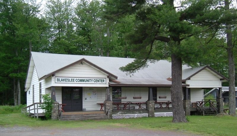
Built in 1922, this site has been the center and single most important structure for
hosting Blakeslee area community affairs. It has served as a gathering place for local
clubs, hosting fellowship dinners, public elections, dances, local art and . . . — — Map (db m177487) HM
The oldest congregation in the area first assembled in a log schoolhouse in 1840. A church was built in 1852, when Pastor Frederick Illman presided. In 1897 it was replaced with this building, which was enlarged in 1960. Seventeen stained glass . . . — — Map (db m97303) HM
A privately-owned toll road was chartered in 1803 and completed by 1816. It followed the course of today’s route 115 in our township, with tollgates about every 17-miles. Grain from the Wyoming Valley, lumber from the Poconos, and building plaster . . . — — Map (db m104520) HM
From 1930,families flocked here, to a creekside beach and attractions on both sides of the road: Sporting fields, miniature railroad, carousel, stone skating rink, clubhouse, swimming pools, dining hall and penny arcade. The place was hopping as . . . — — Map (db m104525) HM
Blakeslee was the influential community leader for whom this village was named. He was a merchant, farmer and lumberman, owning several thousand acres. A trustee of the Methodist Church built in 1852, and the town’s first postmaster in 1883, Jacob . . . — — Map (db m97890) HM
Our community pioneered public education before the state mandated it in 1834. A log schoolhouse was built in 1831, with Miss Sarah Winters as the first teacher. Few married women were employed in that era. By 1860, the township’s four schools each . . . — — Map (db m104529) HM
The local landscape was formed over 11,000 years ago by the retreating Wisconsin glacier. As the ice melted, it left behind massive boulders and rocks, known as “drift deposits”. This geological event created vast areas of swampy land . . . — — Map (db m104530) HM
The area’s vast timber resources spawned a myriad of wood-related industries. 30 sawmills existed in 1830. With increasing demand, larger sawmills and specialty production opened, including a clothespin factory. Over 20 products were made, such as . . . — — Map (db m104540) HM
In 1926, Lutherans from the NY metro area created a vacation site dedicated to Christian values. This was the entrance to over 1,300 acres on which their dream was realized. A lake, hotels, youth camps, and family cottages were built in a pristine . . . — — Map (db m97156) HM
This burial ground has served the surrounding area since the Civil War era. A walk among the markers takes you back in time. Here lie those who built our community. Some worked in logging, ice harvesting or farming. Some founded schools, churches, . . . — — Map (db m85408) HM
Ice was harvested on local lakes from 1896 thru the 1940s. Vast icehouses insulated with sawdust at Naomi Lake, Pocono Lake, Stillwater Lake, Anglewood lake and Brady’s Lake kept tons of ice frozen through summer. Blocks of ice were shipped by rail . . . — — Map (db m104537) HM
Stauffer (1834-1919) engaged in lumbering on an enormous scale, reinvesting his profits in land. He accumulated over 4,000 acres in this area. Business ventures included manufacturing, a saw mill, ice companies and Pocono Lake’s first phone company. . . . — — Map (db m104545) HM
This 1883 building, initially the German Reformed Church, is the oldest surviving religious structure in the area, with the original bell still in its steeple. Legendary Pocono businessman Isaac Stauffer was a founder. Land donated by Charles Gravel . . . — — Map (db m92320) HM
The First Fire Company
Built in 1935, the Pocono Pines Fire Company included offices for police, township supervisors and support staff. Its Goodwill Community Club offered space for public “meetings, suppers and various . . . — — Map (db m104528) HM
Pocono timberlands, trees as far as the eye could see, laid the foundation of soaring commerce during the latter half of the 19th century. Innovative and energetic logging of mammoth white pine, eastern hemlock and hardwoods fueled the growth of . . . — — Map (db m96410) HM
The first permanent settlers were attracted to this area by an abundance of natural resources: land, trees, water. The township was incorporated in 1830, with 230 residents. It was named after Tobyhanna Creek, “A stream lined with . . . — — Map (db m104538) HM
In 1888, George E. Wagner founded this tree farm on 1,700 acres. He and his son, Sterling R. Wagner, achieved recognition in the fields of forestry and conservation. A WB&E rail spur provided an outlet for forest products, coal, blueberries, and . . . — — Map (db m97721) HM
During the Civil War, Christman of Pocono Lake enlisted in the 67th Regiment of the Pennsylvania Volunteers. He sent his military pay and enlistment bonus to his penniless parents so they could buy land for a family home and farm. On May 13, 1864 . . . — — Map (db m103670) HM
Franklin Comfort Miller opened a summer resort on this site in 1888. His beautiful Victorian hotel offered guests lush woodlands, pure streams and healthy spring water. Naomi Lake (1895) added swimming and boating. Room cost of $8 weekly included . . . — — Map (db m104543) HM
An independent “Chautauqua” was organized in 1902 by followers of Rev. Rufus W. Miller. Occupying 300 acres, it was initially named “Naomi Pines Assembly and Summer Schools”. Hotels. Auditorium and a library provided . . . — — Map (db m104490) HM
General John Sullivan’s 1779 Revolutionary War expedition built a road through this area. Only one bridge was required from Easton to Wilkes-Barre, and it crossed Tobyhanna Creek here. Camped nearby, over 500 troops completed the difficult . . . — — Map (db m103664) HM
After 1900, Pocono camps became popular destinations for children from outside this area. Recreation activities including swimming, boating, riding and sports. “Sleep away” experience was a first for most campers. Pocohanna, Owaissa, . . . — — Map (db m95755) HM
On August 2, 1784, a battle was fought here in the 3rd Yankee-Pennamite War. After a brutal winter, the Yankee Settlers were forcibly pushed from their homes in the Wyoming Valley by the Pennsylvania Militia. As a result, a battle of the campaign to . . . — — Map (db m97711) HM
A log-framed inn served travelers on Sullivan Road, circa 1850. Rooms, food and drink were available. It also housed church services and a post office for the town, then known as Tompkinsville. Operated by Frederick P. Miller and his son Timothy, . . . — — Map (db m97597) HM
This encampment site was named by General Sullivan’s Expedition of the Revolutionary War, 1779, en route north to avenge the Wyoming Massacre. They called the adjacent swamp Hell’s Kitchen. Army engineers built this first road on the Pocono Plateau, . . . — — Map (db m84565) HM
In 1893 a single track line was built from Wilkes-Barre to Stroudsburg. It was the shortest route to a connecting line, taking anthracite coal to tidewater ports in New Jersey for domestic and export markets. With stations at Naomi Pines, Pocono . . . — — Map (db m104547) HM