4 entries match your criteria.
South Carolina, Calhoun County Historical Commission/Society Historical Markers
By Mike Stroud, January 3, 2010
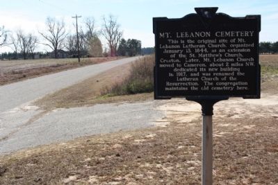
Mt. Lebanon Cemetery Marker, looking west along Mt. Lebanon Road
| On Mt. Lebanon Road, 0.5 miles west of Old State Road (U.S. 176), on the right when traveling west. |
| On Cameron Road (State Highway 33) near Nate's Store Road (State Highway 9-27), on the right when traveling east. |
| On South Railroad Avenue (State Highway 9-48) at Dantzier Street, on the right when traveling south on South Railroad Avenue. |
| On Waterspring Road (State Highway 38-142) near Lime Kiln Road, on the left when traveling east. |
Apr. 26, 2024