On Priory Row at Cuckoo Lane, on the left when traveling east on Priory Row.
11 Priory Row
Early 18th century town house with fine brick front and stone dressings in Roman Ionic style, rebuilt and restored after extensive bomb damage this house with nearby Nos 7 and 16 Little Park Street are the only surviving examples of . . . — — Map (db m124733) HM
On Bayley Lane at Cuckoo Lane, on the left when traveling west on Bayley Lane.
22 & 23 Bayley Lane
No 22 ‘The Cottage’ built about 1500 is the only remaining example of numerous medieval timber framed houses which stood in this area.
Notable for its original carved and traceried woodwork. Chimneys were added in the 17 . . . — — Map (db m124728) HM
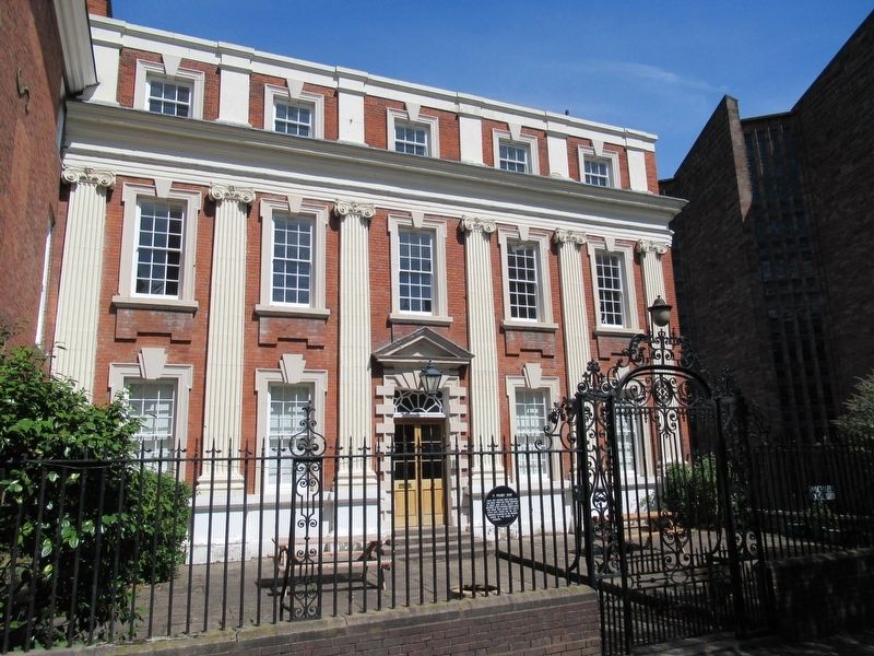
On Priory Row at Cuckoo Lane, on the right when traveling west on Priory Row.
7 Priory Row
Built circa 1800, this house with Nos 8-10 Priory Row are the best surviving examples of late 18th century town houses in Coventry John Gulson Mayor 1867 and 1868 a generous public benefactor lived here 1835-1904 — — Map (db m124735) HM
On Priory Row at Cuckoo Lane, on the left when traveling east on Priory Row.
9-10 Priory Row
Fine examples of early 19th century town houses. built over part of the site of the Cathedral Priory of St Mary founded 1043. Cellars under this house include parts of the priory ruins, approximately 4 metres (13ft) below the . . . — — Map (db m124734) HM
Near Trinity Street at New Buildings, on the left when traveling south.
Blue Coat School
Opened as a charity school in 1714 rebuilt on the same site 1856-7 with Gothic architecture in the style of a French chateau. The two octagonal stone towers embody bases of towers of the ruined Monastic Church of St Mary dating . . . — — Map (db m124905) HM
Near Bayley Lane at St Mary Street, on the left when traveling north.
The Cathedral Church of St Michael
A house of worship, dedicated to the Archangel, St Michael, has stood on this site from the time of Henry I in the 12th Century. From its beginnings as a small Norman chapel, St Michael's progressively enlarged, . . . — — Map (db m124653) HM WM
Near Bayley Lane at St Mary Street, on the left when traveling north.
Chor der
Überlebenden
Choir of Survivors
Geschenk Der Stiftung Frauenkirche Dresden Zum 50-Jährigen
Jubiläumder Weihe Der St. Michael’s-Kathedrale Von Coventry
Am 25. Mai 2012
Donation of the Frauenkirche Foundation Dresden
For the . . . — — Map (db m124647) HM
On New Union Street at Greyfriars Lane, on the right when traveling west on New Union Street.
This Tower and Spire formed the centre of the Church of the Grey Friars built in 1350 with stone from a quarry nearby owned by the Black Prince.
The Friary was demolished in 1512 but the spire was left standing in a garden until 1829 when . . . — — Map (db m124934) HM
On Bayley Lane close to Cuckoo Lane, on the right when traveling west.
County Hall
Built 1783-4 architect Samuel Eglinton. Used for the county court and quarter sessions. It is the only remaining 18th century public building of architectural distinction in Coventry. At one time it also housed the prison governor of . . . — — Map (db m124732) HM
Near Bayley Lane at St Mary Street, on the left when traveling north.
Coventry Cathedral – Living Icon of Reconciliation and Hope
In 1940 this building, together with much of the city, was destroyed by fire bombs. Resolved to live out the Christian message of forgiveness, and running counter to the feelings of . . . — — Map (db m124659) HM WM
Near Greyfriar’s Lane at High Street, on the left when traveling north.
‘He was ahead of his time. What he did astonished the world. Coventry desperately needed his inspiration’
Gibson, Sir Donald Evelyn Edward, C.B.E., D.C.L., M.A., P.P.R.I.B.A., D.I.S.T., T.P., M.T.P.I., T.P.I.
Born 11th October 1908, Died . . . — — Map (db m124560) HM
On New Union Street at Greyfriars Lane, on the right when traveling west on New Union Street.
This plaque was unveiled by the Lord Mayor of Dresden Herr Gerhard Schill in the presence of His Excellency the Ambassador of the German Democratic Republic Herr Karl-Heinz Kern and the Right Worshipful the Lord Mayor of Coventry Councillor G.W. . . . — — Map (db m124933) HM
Near Bayley Lane at St Mary Street, on the left when traveling north.
Ecce Homo
The ststue was carved by Sir Jacob Epstein during 1934 – 5 from a block of Subiaco marble. It was given to Coventry Cathedral at the wish of Lady Epstein and dedicated on 22 March 1969.
Ecce Homo represents Christ before Pilate . . . — — Map (db m124658) HM
On Greyfriars Lane at Barracks Way, on the left when traveling south on Greyfriars Lane.
Ford’s Hospital
Named after William Ford who’s will of 1509 endowed the almshouses. Built around a narrow court yard it is one of the most perfect examples of timber framed architecture in the country. Badly damaged by an air raid of November 1940 . . . — — Map (db m124930) HM
Near Greyfriars Lane at High Street, on the left when traveling north.
Self-sacrifice
Godiva
She rode forth clothed with
Chastity: the deep air listen’d round
Her as she rode and all the low wind
Hardly breathed for fear Tennyson
Godiva
Then she rode back clothed on with
Chastity … . . . — — Map (db m122584) HM
On Pepper Lane at Hay Lane, on the left when traveling west on Pepper Lane.
The Golden Cross Inn
Built circa 1583. Much restored, one of the most dramatic examples of medieval timber framed building to survive in Coventry with oversailing or ‘jettied’ upper floors on exposed timbers — — Map (db m124731) HM
On England Route B4544 at Bull Yard, on the right when traveling north on State Route B4544.
Bull Yard was formally a short street (Bull Street) leading to Barracks Square Market (now the Barracks car park), but on Samuel Bradford’s 1748-49) Coventry map it was part of a much longer path leading from Greyfriars gate to Smithford Street, . . . — — Map (db m124937) HM
Near Bayley Lane at St Mary Street, on the left when traveling north.
In
gratitude to God
and to commend
to future generations
the self-sacrifice of
all those who served
on the Homefront
during the Second
World War
( inscribed on the perimeter )
Let each of you look not to your own . . . — — Map (db m124648) WM
Near Priory Row at Trinity Lane, on the right when traveling west.
Godiva, Lady of Coventry
(died 10th September 1067) and her husband
Leofric, Earl of Mercia
(died 28th September 1057) were buried here in the church of the
Benedictine monastery they founded in 1043 on the site of St Osburg’s nunnery, . . . — — Map (db m124907) HM
On Hales Street at Fairfax Street, on the left when traveling north on Hales Street.
Lady Herbert’s
Garden & Garden of
International Friendship
Lady Herbert’s Garden was laid out in the 1930s by Alfred Herbert as a memorial to his second wife. The garden of International Friendship was opened in 2000 as part of the City . . . — — Map (db m124941) HM
Near Priory Row close to Trinity Lane, on the right when traveling west.
The north side of the nave was rebuilt in Gothic style in the early 13th century. Pointed arches were supported on typically diamond-shaped bases. The piece of stone on display represents the Gothic architecture of much of the cathedral and . . . — — Map (db m124913) HM
Near Priory Row at Trinity Lane, on the right when traveling west.
The south side of the nave was built in the 12th century in Norman Romanesque style. The pieces of stone here display the robust Romanesque architecture f this side of the cathedral. The half round shaft is typical of this style and many would . . . — — Map (db m124911) HM
Near Bayley Lane at St Mary Street, on the left when traveling north.
Reconciliation
In 1995, 50 years after the end of the Second World War this sculpture by osefina de Vasconcellos has been given by Richard Branson as a token of reconciliation.
An identical sculpture has been placed on behalf of the people . . . — — Map (db m124652) HM
Near Bayley Lane at St Mary Street, on the left when traveling north.
1914 1918
To the Glorious Memory
Of the Officers and Men of
The 7th Battalions
The Royal Warwickshire Regiment
Who Fell in The Great War
This Tablet was Erected by Their Comrades — — Map (db m124660) WM
On Bayley Lane at St Mary Street, on the right when traveling west on Bayley Lane.
The Ruined Cathedral Church of St. Michael
Dates from 1300AD. One of the largest parish churches in England, built originally for the Earl's Half of Coventry, it became the Cathedral of the Diocese of Coventry in 1918. The magnificent west tower . . . — — Map (db m124727) HM
Near Bayley Lane at St Mary Street, on the left when traveling north.
The Sanctuary, built in the 14th century and destroyed in the 20th. The cross of burnt roof timbers, the cross of nails in the cathedral and the altar of broken stones, are symbols of the Christian hope of resurrection after suffering. The Litany . . . — — Map (db m124657) HM
Near Bayley Lane at St Mary Street, on the left when traveling north.
· · nation
shall not
lift up sword
against nation
— neither shall
they learn war
anymore ·
Micah 4 · 3 ·
1940 Coventry 1990
forward in friendship
This plaque
was unveiled by
Her Majesty
Queen Elizabeth
The . . . — — Map (db m124654) HM
On Trinity Street at Hales Street, on the left when traveling north on Trinity Street.
Air Commodore
Sir Frank Whittle
OM, KBE, CB, FRS, FRAeS
This statue celebrates the centenary
of Frank Whittle’s birth in Coventry and
shows him watching the first test flight of
a jet-propelled Gloster-Whittle E28/39
on 15 May 1941 . . . — — Map (db m124938) HM
On Bayley Lane at St Mary Street, on the left when traveling west on Bayley Lane.
St Mary’s Hall
Built 1340-1460 restored 1824 thought to include parts of a 12 century castle in the south wall. Originally the guild hall and chambers for the merchants guilds of St Mary and Holy Trinity founded 1340 and 1364. Became the first seat . . . — — Map (db m124729) HM
On Bayley Lane at Cuckoo Lane, on the left when traveling west on Bayley Lane.
On this site stood St. Michaels
Baptist Church from 1856 until
November 1940 rebuilt at Quinton
Park, Cheylesmore, Coventry.
New building completed on
original foundations 1991. — — Map (db m124730) HM
On Hales Street close to Fairfax Street, on the left when traveling north.
Completed circa 1440 as part of the fortified town wall, remains of which stand in the adjoining gardens. Originally named Priory Gate it gave access to the Prior’s lands outside the wall, including Swanswell Fishpool. The archways were blocked, . . . — — Map (db m124939) HM
Near Greyfriar’s Lane close to High Street, on the left when traveling north.
‘One of the finest shopping centres in the world’
The shopping precinct in Coventry has been recognised as a model for a number of similar centres throughout the world. It was the world's first large scale pedestrianised shopping area. . . . — — Map (db m124563) HM
Near Priory Row close to Trinity Lane, on the right when traveling west.
The Cloister
The priory cloister was situated on the north side of the cathedral. It formed a square space surrounded by monastic buildings, the most important being the chapter house on the east side. The cloister was important for its seclusion . . . — — Map (db m124914) HM
On High Street at Earl Street, on the left when traveling east on High Street.
The Council House
Built 1913-17. The red sandstone facing and early tudor styling was chosen by a competition to be in keeping with nearby St Mary’s Hall. The large porch is flanked by guilded armorial decoration under giant figures of Leofric and . . . — — Map (db m124554) HM
Near Trinity Street close to Hales Street, on the left when traveling north.
The Coventry Theatre
The New Hippodrome, as it was originally named, was opened on 1 November 1937. It was the third Hippodrome on this site, the first situated in Pool Meadow (1903) and the second (1907) built in what is now the lower part of Lady . . . — — Map (db m124940) HM
Near Bayley Lane at St Mary Street when traveling north.
These chapels were established in the side aisles. They were commissioned in the 14th and 15th centuries for thee use of the Mercantile Guilds in the City.
They were primarily chantries – endowed chapels in which Masses were sung for . . . — — Map (db m124661) HM
Near Priory Row close to Trinity Lane, on the right when traveling west.
Coventry City Council
The Lychgate Cottages
Named after the lychgate, through which funerals once entered Holy Trinity graveyard (Old English lic – corpse). The jetted building has been tree-ringed dated to 1414-15 and is the only . . . — — Map (db m124906) HM
Near Priory Row close to Trinity Lane, on the right when traveling west.
To the left are the arches that lead into the north west tower, constructed in the early 13th century. This is the only ‘room’ surviving from the cathedral. It may have contained a chapel reached via a pointed arch from the north aisle. The two . . . — — Map (db m124910) HM
On England Route B4544 close to Greyfriars Road, on the right when traveling north.
The Quadrant
Built circa 1860. Coventrys finest example of terraced housing for the prosperous middle-classes of that era. The neo-classic terrace is built in six individual sections each with its own variation in design. — — Map (db m124935) HM
Near Bayley Lane close to St Mary Street, on the left when traveling north.
The South Porch
Built around 130, the porch was retained when the main body of the early English Church was demolished in the 14th to 15th centuries. It is now called the Chapel of the Ressurection; dedicated to Bishop Mervyn Haigh in June 1942. . . . — — Map (db m124645) HM
Near Priory Row at Trinity Lane, on the right when traveling west.
There is little left of the south west tower of the cathedral except the west wall and part of the spiral staircase found in 1856. The full plan of the 13th century tower was revealed during the 1999 excavations. The square room at the bottom of . . . — — Map (db m124908) HM
Near Bayley Lane at St Mary Street, on the left when traveling north.
The Statue of Christ
This is a second casting, in concrete, of a statue at Blundell's School in Devon. It was created by an 18 year old pupil Alain John. The Headmaster, Neville Gorton, later became Bishop of Coventry and on the death of Alain . . . — — Map (db m124655) HM WM
Near Bayley Lane at St Mary Street, on the left when traveling north.
The Tower & Spire
St Michaels tower was completed in1394 and the Spire in 1433 and today stands at 294 feet. The 14th century Tower was built on the edge of a quarry on poor ground — jumble of rubble in clay with bits of old stone coffins, . . . — — Map (db m124646) HM
Near Priory Row close to Trinity Lane, on the right when traveling west.
The west front is the best preserved part of the nave. Only the interior of the wall can be seen. It was built in the early 13th century as part of a grand re-fronting of the cathedral. It was discovered in 1856 when the Blue Coat School was being . . . — — Map (db m124909) HM
On Priory Row close to Cuckoo Lane, on the right when traveling west.
You are standing upon the site of three ancient edifices
On the summit of hill top (approximately on this site) a convent was established about the year 650 A.D. By a Saxon lady later canonised under the name of St Osburg. The convent was . . . — — Map (db m125064) HM