Marker Logo HMdb.org THE HISTORICAL
MARKER DATABASE
“Bite-Size Bits of Local, National, and Global History”


After filtering for Newfoundland and Labrador, 3 entries match your criteria.  


Historical Markers in St. Anthony, Newfoundland and Labrador

 
Fox Point Light Station image, Touch for more information
By Barry Swackhamer, June 28, 2014
Fox Point Light Station
1 Newfoundland and Labrador, Great Northern Peninsula, Newfoundland, St. Anthony — Fox Point Lightouse(Fishing Point)
On West Street, on the left when traveling east.
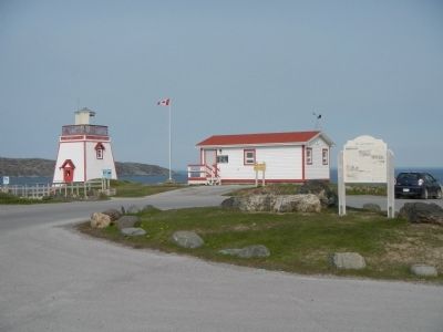
In 1912, a light was established at the south entrance of St. Anthony Harbour replacing the original harbour light placed there in 1906. The white occulting light was installed in a cast-iron light tower. It exhibited 20.5 meters (67 feet) above . . . Map (db m79667) HM
2 Newfoundland and Labrador, Great Northern Peninsula, Newfoundland, St. Anthony — Sir Wilfred Thomason Grenfell1865-1940
On West Street close to Hospital Road, on the right when traveling east.
English: Born in England and trained in medicine, Grenfell gave 50 years of service to the people of northern Newfoundland and Labrador, and became a legend in his own time. He and those he inspired brought medical, spiritual and . . . Map (db m79610) HM
3 Newfoundland and Labrador, Great Northern Peninsula, Newfoundland, St. Anthony — St. AnthonyPopulation 2,996 (1996)
On West Street, in the median.
St. Anthony Haven By tradition St. Anthony harbour was named by French explorer Jacque Cartier in 1534. Indeed, it is probable that the long, deep and sheltered harbour was already well-known to fishermen of the French province . . . Map (db m79668) HM


CeraNet Cloud Computing sponsors the Historical Marker Database.
This website earns income from purchases you make after using our links to Amazon.com. We appreciate your support.
Paid Advertisement
May. 8, 2024