Near Winchester in Frederick County, Virginia — The American South (Mid-Atlantic)
The Third Battle of Winchester
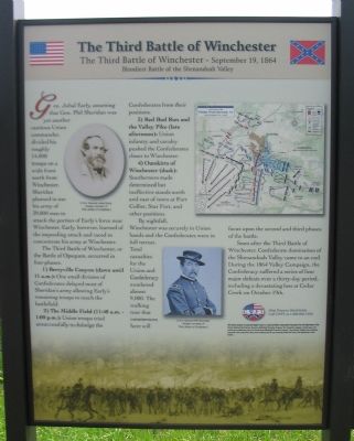
(Left Side): The Third Battle of Winchester - September 19, 1864
Bloodiest Battle of the Shenandoah Valley
Gen. Jubal Early assuming that Gen. Phil Sheridan was yet another cautious Union commander, divided his roughly 14,000 troops on a wide front north from Winchester. Sheridan planned to use his army of 39,000 men to attack the portion of Early's force near Winchester. Early, however, learned of the impending attack and raced to concentrate his army at Winchester.
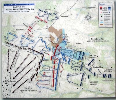
The Third Battle of Winchester, or the Battle of Opequon, occurred in four phases:
1) Berryville Canyon (dawn until 11 a.m.): One small division of Confederates delayed most of Sheridan's army allowing Early's remaining troops to reach the battlefield.
2) The Middle Field (11:40 a.m. - 1:00 p.m.): Union troops tried unsuccessfully to dislodge the Confederates from their positions.
3) Red Bud Run and the Valley Pike (late afternoon): Union cavalry and infantry pushed the Confederates closer to Winchester.
4) Outskirts of Winchester (dusk): Southerners made determined but ineffective stands north and east of town at Fort Collier, Star Fort, and other positions.
By nightfall, Winchester was securely in Union hands and the Confederates were in full retreat. Total casualties for the Union and Confederacy numbered almost 9,000. The walking tour that commences here will focus on the second and third phases of the battle.
Soon after the Third Battle of Winchester, Confederate domination of the Shenandoah Valley came to an end. During the 1864 Valley Campaign, the Confederacy suffered a series of four major defeats over a thirty-day period, including a devastating loss at Cedar Creek on October 19th.
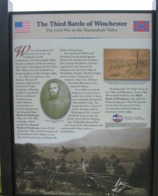
(Right Side): The Third Battle of Winchester - September 19, 1864
The Civil War in the Shenandoah Valley
With rich farmland that earned it the name "the breadbasket of the Confederacy," the Shenandoah Valley formed a natural corridor for military movements. Throughout the Civil War, 1861-1865, Union and Confederate armies fought over this strategic valley.
In 1862 Confederate Gen. Thomas "Stonewall" Jackson (right) led the best-known Valley Campaign. Although usually outnumbered, his forces defeated Federal troops, under different commanders, in several engagements, including the First Battle of Winchester (May 25). The 1863 campaign, which included the Second Battle of Winchester (June 13-15), cleared the Valley of Union troops and let the Confederate Gen. Robert E. Lee slip into Pennsylvania, resulting in the Battle of Gettysburg.
The summer of 1864 found Abraham Lincoln pitted against Democratic presidential candidate Gen. George McClellan. Lincoln's largest force, the Army of the Potomac, was mired in a siege of Petersburg, Virginia. Northern hopes were revived on September 2, however, when Gen. William Tecumseh Sherman's army captured Atlanta.
In an effort to seize the initiative, Lee sent a force under Gen. Jubal A. Early on a campaign through the Shenandoah Valley. Lee hoped that Gen. Ulysses S. Grant, fearing a raid on Washington, D.C., would divide his army to meet the threat. Grant did so; charging Gen. Philip Sheridan and his new Army of the Shenandoah with rendering the Valley useless to Confederates.
On September 19, Early's Army of the Valley and Sheridan's Army of the Shenandoah clashed at the Third Battle of Winchester, also called the Battle of Opequon. Third Winchester was the first of a series of Union victories that ended Confederate domination of the Valley.
Erected by Civil War Preservation Trust.
Topics and series. This historical marker is listed in this topic list: War, US Civil. In addition, it is included in the Battlefield Trails - Civil War series list. A significant historical month for this entry is September 1893.
Location. This marker has been replaced by another marker nearby. It was located near 39° 12.605′ N, 78° 7.648′ W. Marker was near Winchester, Virginia, in Frederick County. Marker was on Redbud Road (Route 661), on the right when traveling east. Located at the beginning of the walking trail, in the north parking lot, for the CWPT's Winchester battlefield site. Additional markers along the walking trail are included in the related markers section. Touch for map. Marker was in this post office area: Winchester VA 22603, United States of America. Touch for directions.
Other nearby markers. At least 8 other markers are within walking distance of this location. The Northern Flank (here, next to this marker); a different marker also named Third Battle of Winchester (a few steps from this marker); The Association for the Preservation of Civil War Sites (APCWS) (a few steps from this marker); "Like A Thousand Bricks" (within shouting distance of this marker); Ritchie Interpretive Plaza (within shouting distance of this marker); Three Battlefields (within shouting distance of this marker); The First Battle of Kernstown (about 300 feet away, measured in a direct line); The First Battle of Winchester (about 300 feet away). Touch for a list and map of all markers in Winchester.
More about this marker. All of the Civil War Preservation Trust signs on the Third Winchester Battlefield have been removed and replaced with new ones placed by the Shenandoah Valley Battlefields Foundation.
The left side of the marker displays portraits of "C.S.A.

4. Help Preserve 3rd Winchester
Details of CWPT efforts to save this battlefield.
Click for more information.
Click for more information.
On the right side is a portrait of Gen. Thomas Jackson and "Alfred Waud's depiction of the First Kernstown, "Stonewall" Jackson's first battle in his Valley Campaign."
Regarding The Third Battle of Winchester. This marker is one of a set duplicated also at the South Side entrance to the battlefield site.
Additional markers along the trail of the battlefield are linked through the related markers list below, and form a Virtual Tour of the battlefield by marker.
Related markers. Click here for a list of markers that are related to this marker. Take a Virtual Tour by Markers of the CWPT's Third Winchester Battlefield.
Also see . . .
1. Third Winchester. The National Parks Service further breaks down the battle into ten phases, and provides more detail to the overall battle. (Submitted on October 22, 2007, by Craig Swain of Leesburg, Virginia.)
2. Third Battle of Winchester Photo-Tour. Site features photographs of the battle sites, including those outside the CWPT Battlefield site. (Submitted on October 27, 2007, by Craig Swain of Leesburg, Virginia.)
Photographed By Craig Swain, August 25, 2007
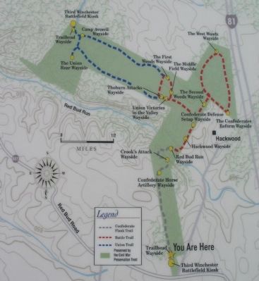
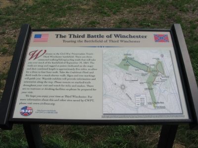
5. Touring the Battlefield of Third Winchester
Not strictly an "historical marker," but included as to display the location of related markers along the trail. It is located at the trail head on the left side. The marker reads:
Welcome to the Civil War Preservation Trust's Third Winchester battlefield. There are three connected walking/hiking/cycling trails that will take you over much of the battlefield of September 19, 1864. The trails are steep and rugged at points (indicated on the map) and their combined length is approximately five miles, so allow for a three to four hour walk. Signs and tree markings will guide you. Wayside exhibits will provide information and orientation along the way. Please remain on the marked trails throughout your visit and watch for ticks and snakes. There are no restrooms or drinking facilities so please be prepared for your visit.
We hope you enjoy your time at Third Winchester. For more information about this and other sites saved by CWPT, please visit www.civilwar.org.
Help Preserve Battlefields
Call CWPT at 1-888-606-1400
Photographed By Craig Swain, August 25, 2007
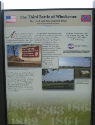
7. Informational Marker, Left Pane
Just to the right of the marker is an informational kiosk marker detailing the efforts of the CWPT:
The Third Battle of Winchester
The Civil War Preservation Trust
Preserving National Treasures
All across the United States, new construction and urban sprawl threaten the Civil War battlefields where more than 600,000 American soldiers gave their lives. Twenty percent of these hallowed grounds have already been obscured by shopping malls, parking lots, amusement parks, and other suburban conveniences. The federal government protects only 15 percent of Civil War Battlefields. Only 42 of the 384 battlefields identified as significant by the federal government are preserved as national parks.
The Civil War Preservation Trust is the only private national organization devoted to protecting our Civil War Battlfeilds. By acquiring endangered sites and promoting preservation through education and example, the Trust helps keep history alive. Through its efforts, sites like Third Winchester Battlefield are saved so that future generations can enjoy them, and appreciate the struggles and sacrifices of our ancestors.
Photographed By Craig Swain, August 25, 2007
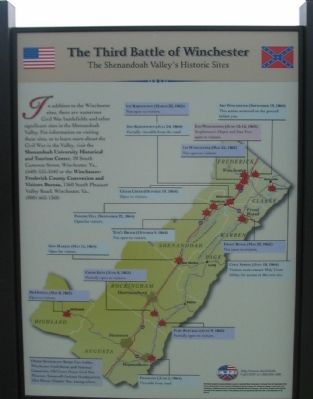
8. Informational Marker, Right Pane
The right side of the informational kiosk indicates other significant sites in the Shenandoah Valley:
The Third Battle of Winchester
The Shenandoah Valley's Historic Sites
In addition to the Winchester sites, there are numerous Civil War battlefields and other significant sites in the Shenandoah Valley. For information on visiting these sites, or to learn more about the Civil War in the Valley, visit the Shenandoah University Historical and Tourism Center, 20 South Cameron Street, Winchester, Va., (540) 535-3542 or the Winchester-Frederick County Convention and Visitors Bureau, 1360 South Pleasant Valley Road, Winchester, Va., (800) 662-1360.
Photographed By Craig Swain, August 25, 2007
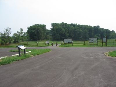
9. Markers in the North Parking Lot
The main marker from this page stands on the right side of the trail head. The trail map marker is just to the left of the trail head. Finally the interpretive marker kiosk is on the right next to the CWPT Battlefield site sign.
Credits. This page was last revised on July 29, 2022. It was originally submitted on October 22, 2007. This page has been viewed 2,746 times since then and 37 times this year. Last updated on October 26, 2020, by Bradley Owen of Morgantown, West Virginia. Photos: 1, 2. submitted on October 22, 2007, by Craig Swain of Leesburg, Virginia. 3. submitted on January 15, 2008. 4. submitted on March 13, 2009, by Craig Swain of Leesburg, Virginia. 5, 6, 7, 8, 9. submitted on October 22, 2007, by Craig Swain of Leesburg, Virginia. • J. Makali Bruton was the editor who published this page.
