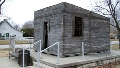
Council Grove in Morris County, Kansas — The American Midwest (Upper Plains)
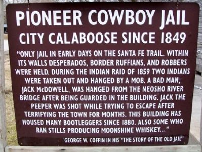
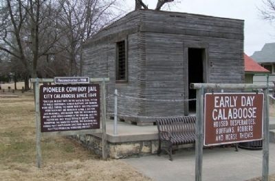
Pioneer Cowboy Jail
City Calaboose Since 1849
"Only jail in early days on the Santa Fe Trail. Within its walls desperados, border ruffians, and robbers were held. During the Indian Raid of 1859 two Indians were taken out and hanged by a mob. A bad man, Jack McDowell, was hanged from the Neosho River Bridge after being guarded in the building. Jack the Peeper was shot while trying to escape after terrifying the town for months. This building has housed many bootleggers since 1880. Also some who ran stills producing moonshine whiskey…"
George W. Coffin in his "The Story of the Old Jail"
———————
Early Day Calaboose
Housed desperados, ruffians, robbers and horse thieves
Erected by Council Grove Chamber of Commerce and Tourism.
Topics and series. This historical marker is listed in these topic lists: Law Enforcement • Native Americans • Wars, US Indian. In addition, it is included in the Santa Fe Trail series list. A significant historical year for this entry is 1859.
Location. 38° 39.71′ N, 96° 28.844′ W. Marker is in Council Grove, Kansas, in Morris County. Marker is at the intersection of Main Street (U.S. 56) and 5th Street, on the left when traveling east on Main Street. Marker is in Durland Park. Touch for map. Marker is in this post office area: Council Grove KS 66846, United States of America. Touch for directions.
Other nearby markers. At least 8 other markers are within walking distance of this marker. Sylvan Park Depot (a few steps from this marker); Company "C" 137th Infantry (approx. 0.2 miles away); Council Oak (approx. 0.2 miles away); Council Grove (approx. 0.2 miles away); Santa Fe Trail / Council Grove (approx. 0.2 miles away); a different marker also named Council Oak (approx. 0.2 miles away); Bur Oak (approx. ¼ mile away); a different marker also named Bur Oak (approx. ¼ mile away). Touch for a list and map of all markers in Council Grove.
Also see . . .
1. Our Rich History. Council Grove Area Trade & Tourism Association website entry (Submitted on July 24, 2011, by William Fischer, Jr. of Scranton, Pennsylvania.)
2. 8 Wonders of Kansas History: Council Grove, Santa Fe Trail National Historic Landmark. Kansas Sampler Foundation website entry (Submitted on July 24, 2011, by William Fischer, Jr. of Scranton, Pennsylvania.)
3. Santa Fe National Historic Trail. National Park Service website entry (Submitted on July 24, 2011, by William Fischer, Jr. of Scranton, Pennsylvania.)
Additional commentary.
1. Pioneer Cowboy Jail
I am a local historian in Council Grove and I was recently writing an article about Jack McDowell who was supposedly held in this jail. I must inform our readers that the information on the sign in front of this jail is incorrect.
The sign states that it has served the 'city' as a jail since 1849. There was no city here in 1849. Seth Hays had his log house out of which he traded with the Kaw Indians. A man by the name of Kennedy who was also a trader had come here by '49. It is also probable that the Choteau brothers were here trading then.
Outside of these four traders there was no town here in 1849.
A few more settlers trickled in to the Grove in 1851-2 and then more people decided to settle here when Kansas became a territory in 1854. Prior to Kansas becoming a territory of the United States there was no authority for anyone here to arrest or hold a person in jail. It wasn't until 1855 that Council Grove had an election of members for the territorial legislature and that a Post Office was established here.
The calaboose that we have today in Durland Park Council Grove was actually built in 1870. One of our most reputable local historians Ken McClintock has found a Town Council report of 1870 that states the jail was built that year. Even Lalla Brigham was closer to correct when she had the construction date at 1871 as stated in her book 'History of Council Grove.'
McClintock thinks the calaboose may have been originally built next to a log guard house which prior to the calaboose was used to hold prisoners. This guard house stood approximately at the south end of present day Washington Street and close by Elm Creek. Whether it was built there or not we do not know for sure, but we do know that in 1873 it was located at the west end of the 300 block of West Main. It can be seen in the 1873 Birds Eye View sketch of Council Grove.
Originally the jail was a two story building. The second floor was the sheriff's office, the staircase was located in what is now the rear of the jail but the front of the jail in 1873.
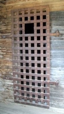
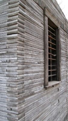
At some point in the recent past, the jail had a major overhaul. The exterior was completely rebuilt as the original structure was rotten and in very poor shape. I am not completely sure of this, but I believe the only original part of the jail is the interior wall and the iron doors and window grates.
— Submitted October 26, 2011, by Derrick Doty of Council Grove, Kansas.
Additional keywords. lynching
Credits. This page was last revised on August 29, 2023. It was originally submitted on July 24, 2011, by William Fischer, Jr. of Scranton, Pennsylvania. This page has been viewed 1,003 times since then and 25 times this year. Photos: 1, 2, 3, 4, 5. submitted on July 24, 2011, by William Fischer, Jr. of Scranton, Pennsylvania.
