Mentor in Lake County, Ohio — The American Midwest (Great Lakes)
Garfield's Farm
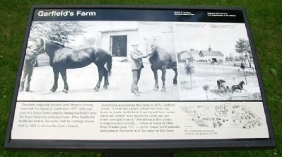
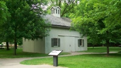
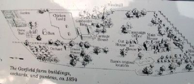
This barn, originally locate near Mentor Avenue, was built for James A. Garfield in 1877. Although part of a larger barn complex during Garfield's time, the horse barn was relocated here. After Garfield's death, his widow, Lucretia, had the carriage house built in 1893 to shelter the farm's horses.
Just before purchasing this farm in 1876, Garfield wrote, "I must get a place where my boys can learn to work, and where I can myself have some exercise, where I can touch the earth and get some strength from it." For the next five years, Congressman Garfield - when at home in Ohio from Washington, D.C. - grew crops, bred animals, and planted orchards with his sons on this farm.
Erected by National Park Service.
Topics. This historical marker is listed in these topic lists: Agriculture • Animals • Man-Made Features • Patriots & Patriotism. A significant historical year for this entry is 1877.
Location. 41° 39.943′ N, 81° 21.063′ W. Marker is in Mentor, Ohio, in Lake County. Marker is on the grounds of James A. Garfield National Historic Site. Touch for map. Marker is at or near this postal address: 8095 Mentor Avenue, Mentor OH 44060, United States of America. Touch for directions.
Other nearby markers. At least 8 other markers are within walking distance of this marker. Railroad Connection (a few steps from this marker); James A. Garfield and the Civil War (within shouting distance of this marker); Lawnfield (within shouting distance of this marker); James A. Garfield's "Lawnfield" (within shouting distance of this marker); Gasholder Building (about 300 feet away, measured in a direct line); Carriage House (about 400 feet away); Windmill (about 500 feet away); Campaign Office (about 600 feet away). Touch for a list and map of all markers in Mentor.
Also see . . .
1. James A. Garfield National Historic Site. (Submitted on November 3, 2011, by William Fischer, Jr. of Scranton, Pennsylvania.)
2. James Abram Garfield at FindAGrave.com. (Submitted on September 16, 2013, by Mike Wintermantel of Pittsburgh, Pennsylvania.)
Credits. This page was last revised on June 16, 2016. It was originally submitted on November 3, 2011, by William Fischer, Jr. of Scranton, Pennsylvania. This page has been viewed 531 times since then and 19 times this year. Photos: 1, 2, 3. submitted on November 3, 2011, by William Fischer, Jr. of Scranton, Pennsylvania.


