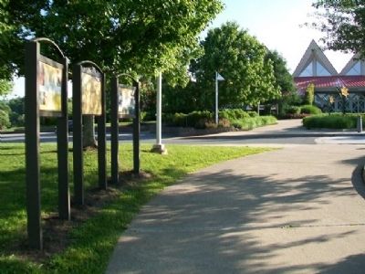
Near Beckley in Raleigh County, West Virginia — The American South (Appalachia)
The Indian Path
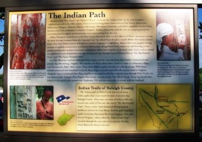
Known as the "War Road", the "Hunter's Road", or simply the "Indian Path" by the time European explorers arrived in the 18th century, Paint Creek had long been a route of travel for Native Americans. Delawares, Mingoes, Ottawas, Senecas, Shawnees, Cherokees, Catawbas, and others regularly traveled Paint Creek to and from settlements in western Virginia. Indians frequently used the area as a staging ground for incursions into European settlements that were encroaching from the east.
When European explorers arrived, Paint Creek abounded with visual evidence of Native American activity, the most obvious evidence being the "painted trees" for which Paint Creek is named. Before European contact, many American Indian nations did not have written languages or alphabets. Some tribes used glyphic writing systems of symbols and pictures to transmit information. Along Paint Creek, many war and hunting parties painted pictographs on trees to transmit information about their exploits, or to mark trails. Early settlers named two prominent areas of painted trees near the present-day Raleigh/Fayette County line as "The Big Painted Trees" and "The Upper Painted Trees".
In 1755, Shawnee warriors abducted Mary Ingles and her two sons from their family's homestead near present-day Blacksburg, Virginia. The warriors led Mary down Paint Creek en route to a Shawnee village near Portsmouth, Ohio. After a time, Mary and a fellow captive carried out a daring escape. With fierce determination and one tomahawk in hand, Mary began a treacherous 450 mile journey back to Virginia. Along the way, it is believed that Mary may have attempted to find her original route through Paint Creek, but was unsuccessful. Instead, Mary began a harrowing journey up the New River Gorge. Mary was found alive lying in a corn patch near present-day Eggleston, VA, and she eventually re-united with her husband.
Indian Trails of Raleigh County
The Indian path on Paint Creek was one of many similar paths that crisscrossed the area of present-day Raleigh County. One major junction of Indian trails was located just north of Pax near the site of "The Big Painted Trees". Here, a major path branched off and headed northwest toward the Coal River. Another path branched south toward the Bluestone River and Virginia. This path toward Virginia - often called the "Paint Creek Trail" - traveled through the east side of present-day Beckley where Kanawha Street is located.
[Photo captions read]
1. This re-creation of an 18th century Delaware (Lenape) Indian war party record depicts a military maneuver in western Virginia. Painted records such as these gave Paint Creek its distinctive name.
Photos by Doug Wood
2. This re-created war record represents the war party of a Delaware (Lenape) warrior named Two Bears. Such records were common throughout eastern North America.
Photos by John Boback
3. This is a re-creation of a Delaware (Lenape) hunting record. The actor is portraying a hunter using charcoal and bear grease as paint. Bark was stripped from a living tree to paint this record, and this was the typical method for making records.
Photo by Ed Robey
Erected by Paint Creek Scenic Trail and America's Byways.
Topics. This historical marker is listed in these topic lists: Colonial Era • Native Americans • Roads & Vehicles • Settlements & Settlers. A significant historical year for this entry is 1755.
Location. 37° 48.117′ N, 81° 12.986′ W. Marker is near Beckley, West Virginia, in Raleigh County. Marker is at Tamarack, the West Virginia cultural heritage and artisan center. Tamarack is accessed from I-77 Exit 45. Touch for map. Marker is at or near this postal address: One Tamarack Park, Beckley WV 25801, United States of America. Touch for directions.
Other nearby markers. At least 8 other markers are within 2 miles of this marker, measured as the crow flies. From Agriculture to Mining (here, next to this marker); Mortality (within shouting distance of this marker); Dinky Locomotive (approx. 1.6 miles away); Raleigh County Coal Mines (approx. 1.6 miles away); Bachelor’s Shanty (approx. 1.6 miles away); Superintendent's House (approx. 1.7 miles away); Samuel B. Antonio (approx. 1.9 miles away); Cleared for Takeoff (approx. 1.9 miles away). Touch for a list and map of all markers in Beckley.
Related markers. Click here for a list of markers that are related to this marker. These markers show Mary Ingle’s journey from her capture to her return.
Also see . . .
1. Paint Creek Scenic Trails Driving Tour. Webside entry (Submitted on July 7, 2014, by William Fischer, Jr. of Scranton, Pennsylvania.)
2. Tamarack Marketplace. Website homepage (Submitted on July 7, 2014, by William Fischer, Jr. of Scranton, Pennsylvania.)
Credits. This page was last revised on January 21, 2022. It was originally submitted on July 7, 2014, by William Fischer, Jr. of Scranton, Pennsylvania. This page has been viewed 1,101 times since then and 100 times this year. Photos: 1, 2. submitted on July 7, 2014, by William Fischer, Jr. of Scranton, Pennsylvania.

